Bisbee to Border and Back is an 18.75-mile loop that starts in Bisbee, Arizona heads toward the Mexican border, and then returns. There are no major climbs, but there are gradual changes in elevation, for a net elevation differential of 582 feet. My apologies for the short distance, but the international border is close enough to limit the distance that a cyclist can ride toward the south, without a passport. Longer rides are available by heading toward the northwest, or east. I will describe one of those in another edition. La Vuelta de Bisbee took advantage of roads in the Bisbee area for years. The race began in 1976, when Bisbee’s mines were closing, and the town needed an economic boost. Bike racing fit neatly into Bisbee’s off-beat culture. During its early years, the race attracted star riders, such as Greg Lemond, and future stars, who burned up the roads in their quest for Bisbee glory. Pro cyclists stopped coming when other, competing races appeared on the calendar. The race was always held in April, same as the now defunct Tour of Georgia, with the latter being more lucrative and prestigious. La Vuelta nonetheless continued into the 2010s, after going on hiatus for a couple of years, scaling back to two road races and two time trials. I was unable to find La Vuelta on this year’s race calendar, but perhaps it will return in the future? Bisbee to Border and Back follows a portion of the former Warren Time Trial.

Despite the distance, the route is filled with history and interest, as well as some fine high desert riding. The history begins at the ride’s staging point, Warren Ballpark, in Bisbee’s Warren district. Warren was Arizona’s first planned community, and there are numerous Arts & Crafts style houses. The community is located in southeastern Bisbee, away from the city’s historical district. Regarding that, Bisbee was founding as a copper, silver, and gold mining town during the 1880s. Mining was so successful that, by 1910, with a population of over 9,000, Bisbee was the largest U.S. city between San Francisco to the west and St. Louis to the east. (Today’s population of 5,575 is about 60% of that of 100 years ago). As for Warren Ballpark, minor league and high school baseball games are held here, in addition to high school football. The ballpark is infamous as the site of the 1917 deportation of 1,300 striking miners. An even larger posse of 2,000 captured the miners and held them at the ballpark, and then deported them to New Mexico, warning them to never return to Bisbee. Although a Presidential commission declared the action to be illegal and without authority, no one was ever convicted.
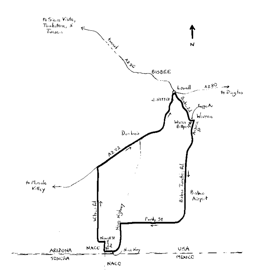
The posse is long gone, but perhaps it would be best to get going on the ride. Start by heading east along Ruppe Avenue, on the north side of the ballpark. Turn right adjacent the northeast corner of the ballpark, onto Arizona Street, and head south. Note that the starting elevation is 4,979 feet. Arizona Street leaves Bisbee within one-quarter mile, heading gradually downhill. You are now on Bisbee Junction Road. At mile 0.75, bear right to remain on Bisbee Junction. The Bisbee Municipal Airport is on the left at mile 2.5. This is a general aviation airport with no commercial service. At mile 4.1, stay to the right – you are now on Purdy Street. The road’s shoulder varies in width. Purdy curves to the right; you are now heading west. At mile 7.05, turn left to head south on Naco Highway, which has a good shoulder. After crossing a railroad track, the highway curves to the right – you are once again heading west, with the Mexican border immediately to the left. This is about as close as you can get!
At mile 8.7, the highway turns to the left – keep straight, which puts you on Towne Avenue. You are now fully in Naco, which is an unincorporated border community. The Mexican border town is also named Naco. There is an international port of entry here. Naco bears the distinction of being the only town in the continental U.S. (i.e., not counting Hawaii) to have been aerially bombed by a foreign force. It was in 1929, when the Escobar Rebellion came to Naco on the Mexican side. Don José Gonzalo Escobar, a general in the Mexican army, planned to overthrow the Mexican government. The rebels hired Irish soldier Patrick Murphy to drop bombs on government forces. His first two bombs were duds, but his third and ensuing bombs hit targets on the U.S. side of the border, destroying several buildings, and causing some road damage. Somewhat humorously, a crowd of several hundred had been gathering daily, some with picnic baskets, to watch the Mexican war from the comfort of the U.S. side. Several folks were hit with shrapnel and other fragments from Murphy’s wayward bombs. No Americans were killed, but there were a number of injuries. After several days of this, Murphy was shot down by Mexican forces, on the Mexican side. He lived, escaped, and fled to the U.S., where he was quickly captured. After being held for a few days, he was released without being charged. After being defeated, Escobar also fled to the U.S., where he sought and was awarded asylum. How is that for forgiveness! Adding to the humor, U.S. military forces reacted slowly. Despite being only 38 miles away, Fort Huachuca’s Buffalo soldiers finally arrived in Naco when the conflict was essentially over.
Back to the ride, Towne Avenue bends 90o to the right in Naco, to head north, away from the border. Turn left onto Newell Street to head west; Newell then bends 90o to the right, becoming Wilson Road. This is the lowest elevation of the ride (4,591 feet). You are now 9.6 miles into the ride, leaving Naco. The road crosses a cattle guard. The shoulder is narrow, but traffic volumes should be minimal. The next 2.8 miles are gradual uphill, across the high desert. At the end of Wilson – there is another cattle guard here — turn right onto Arizona State Highway 92 (AZ 92); you are now heading northeast, toward Bisbee. The highway has a good shoulder. Enter Bisbee at mile 14.15. You may be thinking that Bisbee is very large; it does sprawl, but the area is confined to a narrow strip between adjacent mountains, mines and quarries. The highway widens for a short segment near Naco Highway – the shoulder is lost for about 0.4 miles, but returns when the highway narrows. Pass School Terrace Road at mile 16.75 – this is the highest elevation of the ride (5,173 feet). AZ 92 takes you near Bisbee proper at mile 17.25, as it crosses under an elevated road. As you enter the traffic circle, stay to the right, and then immediately exit to the right, onto Bisbee Road. You are now heading southeast, toward Warren. Follow Bisbee as it passes through Warren, perhaps noticing some of the fine Arts & Crafts bungalows. Bisbee becomes Douglas Street at mile 18.6; Douglas promptly curves to the left, becoming Ruppe Avenue. Warren Ballpark will then be on the right, where the ride ends.
Starting & ending point coordinates: 31.410583oN 109.880242oW
For more Utah rides, see Road Biking Utah (Falcon Guides), written by avid cyclist Wayne Cottrell. Road Biking Utah features descriptions of 40 road bike rides in Utah. The ride lengths range from 14 to 106 miles, and the book’s coverage is statewide: from Wendover to Vernal, and from Bear Lake to St. George to Bluff. Each ride description features information about the suggested start-finish location, length, mileposts, terrain, traffic conditions and, most importantly, sights. The text is rich in detail about each route, including history, folklore, flora, fauna and, of course, scenery.
Wayne Cottrell is a former Utah resident who conducted extensive research while living here – and even after moving – to develop the content for the book.


