By Wayne Cottrell
The Skull Valley Classic is a 110-mile loop featuring a significant climb and descent on a graded dirt road, long false flats through the Tooele and Skull Valleys, and a brief segment along the shoulder of the I-80 freeway in rural western Utah. The elevation ranges from 4,223 feet along I-80, west of Grantsville, to 6,192 feet at Lookout Pass along the Pony Express Trail.
Skull Valley is located west of Salt Lake City, southwest of the Great Salt Lake. The valley is sandwiched between the Cedar Mountains to the west, and the Stansbury Mountains to the east. The legend of Skull Valley is that sun-drenched bones – possibly those of a slaughtered clan of Native-Americans – were discovered by pioneers near Timpie, near the present-day junction of State Highway 196 and the I-80 freeway. The Stansbury Mountains form the western boundary of Tooele Valley, which is the last urban settlement when heading west from Salt Lake for some 100 miles. In between are the broad, arid expanses of the Great Salt Lake Desert – generally inhospitable and lacking development, although there are or have been a few settlements. A large chunk of the desert expanse is consumed by the Dugway Proving Grounds, which is used by the U.S. Army for testing biological and chemical weapons. Also, training flights from Hill Air Force Base, located about 35 miles to the north of Salt Lake City, generally head for the Dugway area.
The Skull Valley Classic is a LONG ride, with few or no provisions along the way, so be sure to bring enough sustenance and liquids for at least six hours in the saddle. Be sure to be mechanically self-sufficient, as well. The ride starts in Grantsville at Grantsville City Park. Grantsville is a pleasant, residential city located 35 miles west of Salt Lake City, and a few miles to the south of I-80. Leave the park by heading west on Cherry Street. Turn left onto Hale Street, and then right onto Durfee Street. The pavement was rough in spots when I checked this route, particularly at the Cooley Street crossing. One mile into the ride, turn left onto West Street and head south. West Street later becomes Willow Road, Mormon Trail Road, and then Main Street. The road surface was fair (i.e., not good, but not poor) when I checked it. Watch out for potholes. Cross a cattle guard shortly after the turn, and begin a gradual uphill. The Stansbury Mountains tower to your right, and the Oquirrh Mountains are off in the distance, to your left. Another cattle guard, at mile 3.6, suggests that this is open range territory. Access to South Willow Canyon is on the right at mile 4.1; one of several canyon roads that penetrates the Stansbury Mountains here, which rise to an astonishing 11,031 feet (Deseret Peak). Cattle guards regularly cross Willow Road (Mormon Trail Road) every 1.5 miles or so. The road finally crests at Hickman Canyon Road (5,470 feet), at mile 11.1.
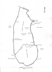
From Hickman Canyon, it is generally downhill. There is not much to see out here, except for the dramatic mountain ranges. Pass through the small community of St. John at mile 16.9, where the road levels. St. John, which later became part of Rush Valley, was one of many towns settled in Utah during the 1850s. Turn left onto State Highway 199 at mile 19. The highway has a narrow shoulder. (Alternatively, to shorten the ride by about 23 miles, to 87 miles, turn right onto State Highway 199. This shorter option follows the route of the Old Lincoln Highway, while the featured option follows the route of the Pony Express. Paved Highway 199 climbs to and descends from Johnson Pass, while straddling the saddle between the Stansbury and Onaqui Mountains. Rejoin the featured ride at State Highway 196, near Dugway). Continuing with the featured route, turn right onto State Highway 36 at mile 20.8, and head south, through Rush Valley. That large array of low domes to your left is the Deseret Chemical Depot, where chemical weapons are stored and destroyed. Mustard gas, anthrax and other poisons have been held here at one time or another. The main piece of advice would be to stay far, far away. Merge with the Pony Express Trail at the intersection with Faust Road, which comes from the left. Turn right about one-half mile later, at mile 32.9, where the signs read “Fish Springs North” and “Pony Express Route.” There is a cattle guard at the turn.
This road, which is literally along the Pony Express route, rolls for a few miles, and then begins to climb at mile 39.9. The pavement ends one-half mile later, as the surface switches to a rideable, graded dirt. There were occasional spots of gravel when I did this route. The road crests at Lookout Pass (elevation 6,192 feet), at mile 41.2. A Pony Express station was once located here. From here, the road descends, steeply for a segment, toward the vast Great Salt Lake Desert. Although this area is indeed remote, there is a steady recreational traffic flow. At the “Y” intersection, at mile 44.7, bear right, toward Dugway, on the aptly-named Dugway Road. You are still riding on dirt, occasionally rough, and there are intermittent cattle guards. Bear right onto Government Creek Road at the end of Dugway Road (no sign) at mile 46.7. The fencing to the left marks the boundary of the Dugway Proving Grounds – totally off limits!
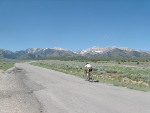
The dirt road (finally) ends at mile 54.3, at the junction with State Highway 199. The community of Dugway (home to about 800 residents), and the entrance to the Proving Grounds, is to your left. Keep straight onto the paved State Highway 196. The Stansbury Mountains are now to your right. The highway stretches out over the horizon, seemingly into infinity. Enter the Skull Valley Indian Reservation (Goshute) at mile 62.7. There is a mini-mart on the right within the reservation. Skull Valley scenery includes livestock, the mountains to your right and far left, an occasional structure, plentiful sagebrush, and the false flats of the broad expanses in front of you. North of the Goshute reservation, however, somewhat off the beaten highway, are the remains of Iosepa. This was a community of converted Polynesians who journeyed from Salt Lake City in the late 19th century to establish their own community. The town survived until 1917 in relatively inhospitable conditions; however, the founding of a Mormon church in Hawaii was the primary reason for the town’s abandonment. Lone Rock, which has an interesting formation, is on the left at mile 85.3. The highway ends at the I-80 freeway, at mile 90.6, just south of Timpie (see above). To return to Grantsville, there is no other choice but to turn right and head east, along the freeway shoulder. Stay to the far right to avoid the rumble strips.
While riding along the freeway, it is possible to see three mountain ranges: the Stansbury Mountains in the foreground, the Oquirrh Mountains in the distance, and the Wasatch Mountains in the far distance. There may be large basins of water to the freeway’s left and right, seemingly having overflowed from the Great Salt Lake. Exit I-80 at exit 84 (“Grantsville”) at mile 97.7 of the ride. The exit ramp makes a loop; turn left at the end. Head into Grantsville on State Highway 138. The highway makes a sharp bend to the left at the 99.9 mile mark. Bonneville Sea Base is near here, on the left. Scuba divers can view tropical fish in geothermally-heated saltwater ponds. After a lengthy stretch, with civilization on the horizon, enter Grantsville at 108.4 miles. Head straight into town; after the road bends to the left, you are now on Main Street. Turn right onto Hale Street at mile 109.6. Turn left at Cherry Street and return to Grantsville City Park to conclude the ride.
 For more rides, see Road Biking Utah (Falcon Guides), written by avid cyclist Wayne Cottrell. Road Biking Utah features descriptions of 40 road bike rides in Utah. The ride lengths range from 14 to 106 miles, and the book’s coverage is statewide: from Wendover to Vernal, and from Bear Lake to St. George to Bluff. Each ride description features information about the suggested start-finish location, length, mileposts, terrain, traffic conditions and, most importantly, sights. The text is rich in detail about each route, including history, folklore, flora, fauna and, of course, scenery.
Wayne Cottrell is a former Utah resident who conducted extensive research while living here – and even after moving – to develop the content for the book.

