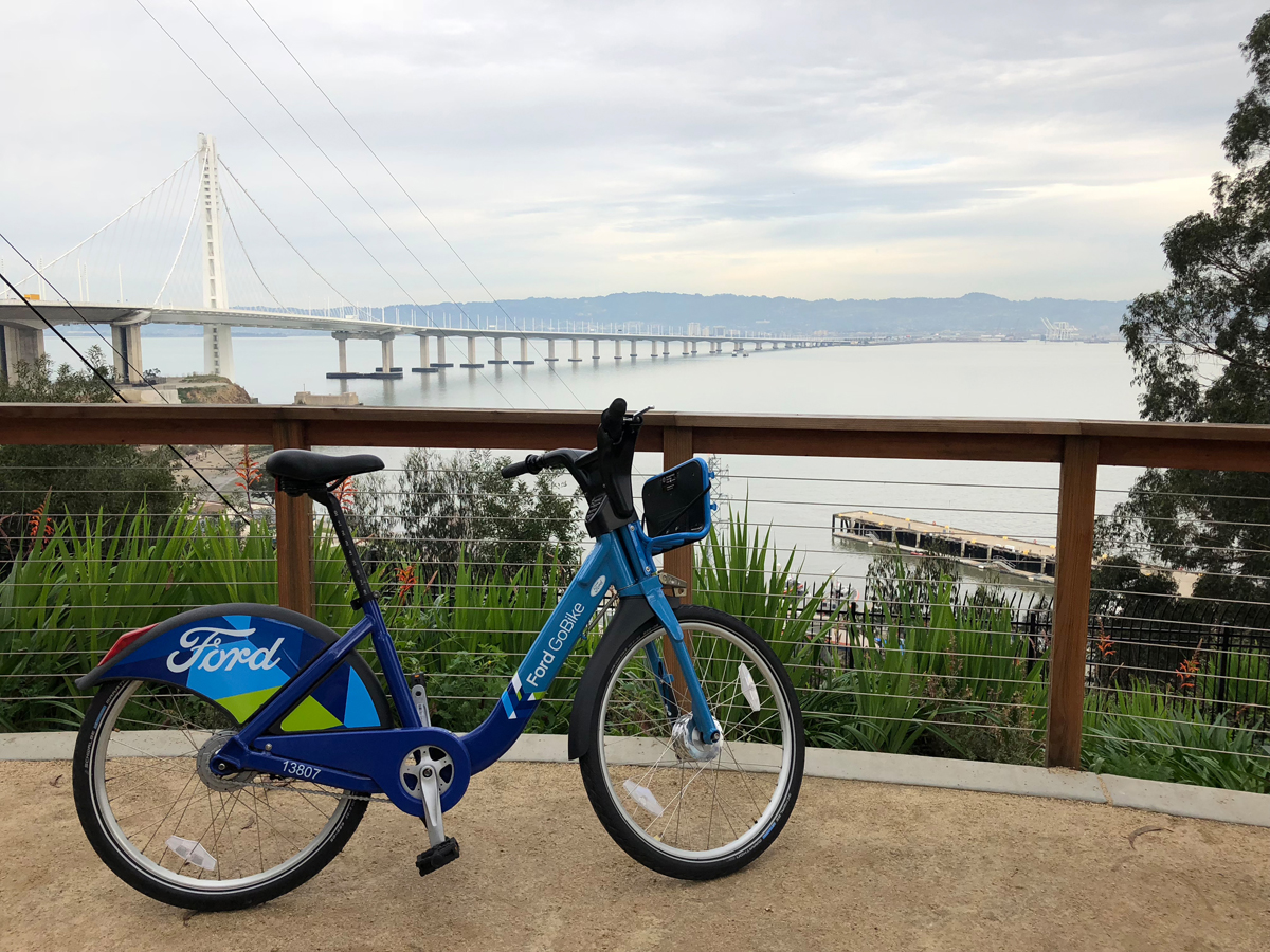
By Wayne Cottrell — This 24.0-mile road bike ride returns us to the San Francisco Bay Area! The route plan includes a lollipop (7.9 miles), followed by an out-and-back (16.1 miles). The Bay Area bike scene is by no means stagnant, as new bike facilities continue to be opened on a steady basis. One of the newer facilities is the Alex Zuckermann Path, which was completed in October 2016 in conjunction with the reconstruction of the eastern half of the San Francisco-Oakland Bay Bridge.

The new, separated bike path makes it possible to ride from the East Bay, across the Bay Bridge to Yerba Buena and Treasure Islands, and back. Sorry — it is not yet possible to ride across the entire Bay Bridge, to San Francisco. I describe a version of this ride in my forthcoming book Best Easy Bike Rides San Francisco. The route described in this article is a slightly longer alternative. The ride should be on your bucket list, as crossing the Bay Bridge on a bicycle is a not-to-be-missed experience. The path is open from 6 am to 9 pm daily (nighttime riding is prohibited).

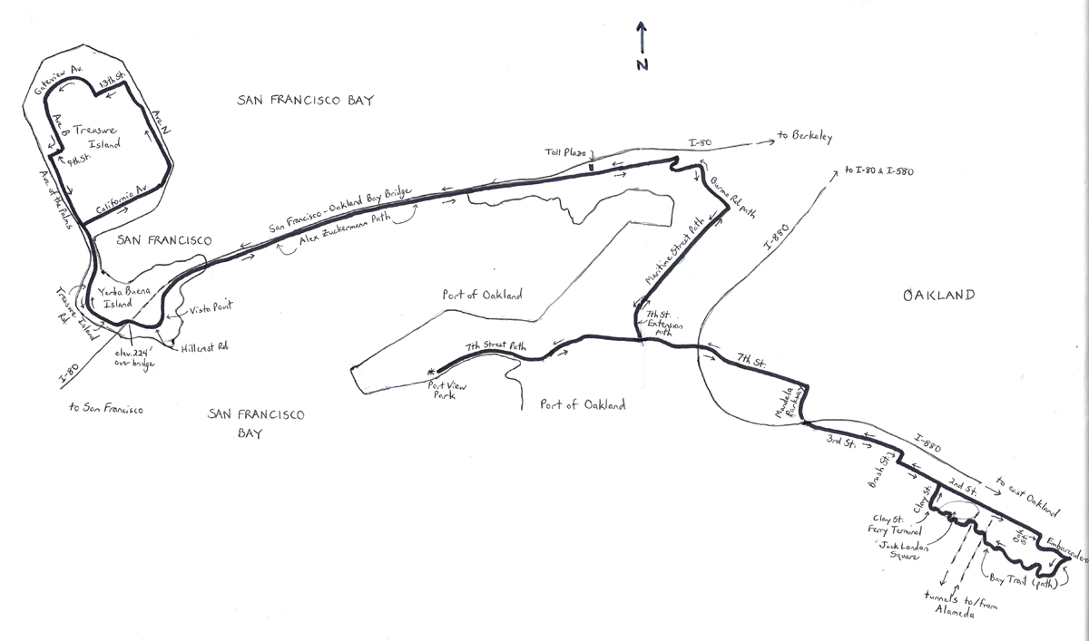
Start the ride at Port View Park in far western Oakland, within that city’s port environment. The Oakland portion of the route uses bike paths, lanes and roads having at-grade crossings. Regarding that, the Port of Oakland teems with trucks and freight trains. It is imperative to be cautious at all road and driveway crossings. There are a few railroad crossings, too. From the park, head away from the waterfront on the 7th Street bike path. Stay on the path as it zigs and then zags, and then crosses a port entry point (watch for trucks), and a couple of railroad crossings. The Bay Area Rapid Transit (BART) Transbay Tube portal is on the right at mile 1.0. This is where BART trains emerge from and initiate their underwater crossings of the Bay.
Keep straight at the traffic signal at 7th Street Extension. The path runs parallel to 7th Street for the next half-mile, crossing more railroad tracks, and passing under the I-880 freeway. The path ends; continue on 7th Street — a bike lane begins after 0.3 miles, after crossing Peralta Street. Turn right on Mandela Parkway; the road passes under I-880, curving left to become 3rd Street, to head east. At Brush Street, turn right (break in the bike lane); the bike lane resumes after you turn left onto 2nd Street.
At about the 3.5-mile mark of the ride, 2nd Street enters Oakland’s Jack London Square district. The Square is not quite as hip as San Francisco’s Fisherman’s Wharf, but there are restaurants, shops, lodging, and the waterfront. Continue heading east on 2nd Street. Turn right on Oak Street — follow the road as It curves left, becoming Embarcadero West. There may be some construction along here. Just prior to crossing Lake Merritt Channel — Oakland Estuary Is to the right — bear right and leave the road (mile 4.35), turning onto the San Francisco Bay Trail (path).
Slow your roll along this next stretch, which uses the Bay Trail, adjacent the waterfront. The ambition of the Bay Trail is to encircle the San Francisco Bay — about 500 miles(!) in length. The Trail was about 70% complete as of this writing. Estuary Park is on the right, as you cruise next to the waterfront. There should be some great views of the Bay and San Francisco.
The path makes a few turns as it hugs the bayfront. Pass over the Posey and Webster Street Tubes (tunnels to Alameda) starting at mile 5.0. Stay adjacent the waterfront as the Bay Trail heads through the Jack London Square district; watch for pedestrians. Leave the waterfront at the Clay Street Ferry Terminal (ferries to San Francisco), now at mile 5.45. Head inland on Clay Street. Turn left on 2nd Street (mile 5.6).
From here, follow the reverse of the outbound route to Maritime Street. Turn right onto the path at Maritime Street to begin the Bay Bridge portion of the ride (mile 7.9) — watch for trucks at entry points, as you are back in the port area At Burma Road, turn left to continue on the path — now parallel to Burma (mile 8.8). At mile 9.05, the path veers away from Burma, crossing a series of railroad tracks, and making a few curves under elevated structures. Turn left onto the Alex Zuckermann Path at mile 9.2.
Zuckermann was the founder of the East Bay Bicycle Coalition. He passed away in 2007 at age 86, five years after crashing while doing an official reconnaissance ride on the bridge, suffering a severe head injury.
The Bay Bridge Toll Plaza is on the right at mile 9.65 — there is no toll for bicyclists. The path is fully on the bridge at mile 10.45, with both beginning to elevate from here. The next 2.2 miles are over water. By the time the bridge reaches Yerba Buena Island, you are 183 feet above the water.
There are plenty of superlatives regarding what you are riding. The bridge is the widest in the world along this stretch; the Yerba Buena Tunnel, through which the I-80 freeway passes, is also the widest in the world. At the end of the path on Yerba Buena Island is Vista Point. This is a favorite gathering and picture spot. From here, shuttles transport cyclists to Treasure Island. It is a convenient, free service for those who are not up to conquering the 5% gradient uphill and downhill on Hillcrest and Treasure Island Roads. Although these roads are narrow and curvy, they are designated as shared facilities, meaning that they can be ridden.
The shuttle bus runs every half hour on weekends and holidays, from 7 am to 6:30 pm. Note that Yerba Buena Island is natural, rugged and steep, while Treasure Island is man-made and pancake flat. The islands adjoin, and are within the city of San Francisco. Treasure Island was built for the 1939 Golden Gate International Exposition, and was then converted into a naval air station.
The segment between Vista Point and Treasure Island, using Hillcrest and Treasure Island Roads, passes the highest elevation of the ride: 224 feet, directly over I-80. This portion of the ride is, perhaps, not for the squeamish, as the roar of the traffic, and the curves and steepness of the road can give the sensation of plunging into the Bay, or maybe even onto the bridge.
Once on Treasure Island (mile 13.7), the route makes a 2.75-mile counterclockwise loop that is easy-breezy. The Treasure Island Museum at right greets you at the start of the loop. It is not possible to ride along the edge of the island, so the ride uses the following sequence of roads: California Street (4th Avenue), Avenue D, Avenue N, 13th Street, Avenue M, Gateway Avenue, Avenue B, and 9th Street to Avenue of the Palms, returning to California (4th). The latter portion of the loop passes through a residential area. There are plans to house 19,000 people(!) on the island; although, in less than one square mile, one wonders where they all will fit.
After completing the loop, be prepared for the 5%-gradient climb up and over I-80, as you return to Yerba Buena Island. The shuttle is an option. The ride continues via the reverse of the outbound route, returning to Port View Park in Oakland.
For more rides in the Bay Area, see Best Bike Rides San Francisco (Falcon Guides), written by avid cyclist Wayne Cottrell. Best Bike Rides San Francisco features descriptions of 40 road and off-road rides in the Bay Area. The ride lengths range from 4 to 60 miles, with rides in San Francisco, the East Bay, and Marin County. Each ride description features information about the suggested start-finish location, length, mileposts, terrain, traffic conditions and, most importantly, sights. The text is rich in detail about each route, including history, folklore, flora, fauna and, of course, scenery. For additional rides in California, all written by Wayne Cottrell, please also see the Best Bike Rides books on Los Angeles and Orange County, as well as the forthcoming Best Easy Bike Rides books on Los Angeles, Orange County, and San Francisco. Wayne Cottrell is a former Bay Area and Utah resident, and current southern California resident, who continues to conduct extensive research in these places, and elsewhere, to develop the content for bike books.


