By John Roberson — In early October of 2023 my sweetheart and I left our Utah home to spend nine delightful days riding the C & O Canal Towpath, a 184-mile, National Park Service historical trail that follows the Potomac River between Washington, D.C. and Cumberland, Maryland. Along the way we experienced fine autumn weather, quiet paths and beautiful riverside scenery. We saw deer and turtles, herons and big black snakes, foggy mornings and lovely sunsets. We shared stories with other bicycle tourists and spent our nights camping in lovely hiker-biker sites along the river. And throughout the tour we were taken both by the ease of the route and by how “wild” the surrounding countryside seemed to us, despite the fact that the towpath passes through one of the more densely-populated parts of our nation.
For roughly 100 years the Chesapeake & Ohio Canal, originally the brainchild of George Washington, provided for the transport by canal boats of goods and commodities between the two cities. Beginning in the 1820s, and continuing for 20-plus years, more than 70 stone locks and aqueducts were constructed, along with lock-houses for the families that operated the locks. Although the canal builders fell short of their original goal to connect Chesapeake Bay to the Ohio River at Pittsburgh, the portions that remain clearly reflect what was an impressive feat of labor and engineering. Canal traffic on the C & O declined with the steady rise of more efficient railroads and stopped completely in 1924 after a series of disastrous floods on the Potomac irreparably damaged the system. The canal and its infrastructure were left to deteriorate until visionaries in the 1950s recognized the potential of the canal as a national pathway worthy of preservation. In 1971 it became a national historical park under the auspices of the National Park Service, and in the years since has served millions of hikers, bikers, runners and other outdoor enthusiasts.
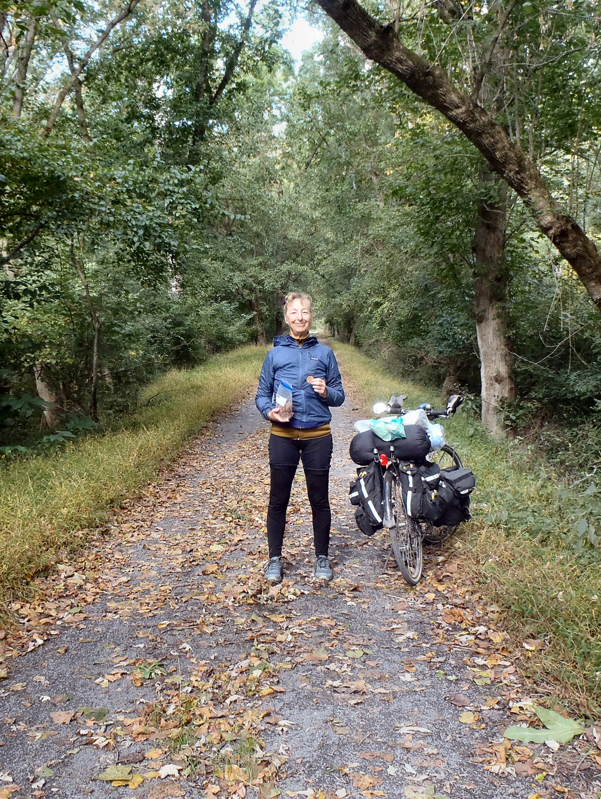
We began our ride in Cumberland and spent the next four days leisurely riding the towpath to Washington, D.C., camping each night along the trail. The weather was perfect and the famous fall foliage of the East had begun to color-up the countryside. We spent two relaxing nights in a Georgetown hotel near the end of the towpath and a day riding around D.C., seeing the sights, doing chores, and marveling at the city’s bicycle-friendly infrastructure. We then spent another four days retracing our route back to Cumberland. The weather was cooler on the ride back, and we had one rainy morning and a couple of misty nights to remind us of the unpredictability of the season. We easily managed about 50 miles each day, which allowed us to stop whenever we felt the urge to check out a nice view, have a snack, take a picture or two, investigate a nearby community, or chat with other towpath users.
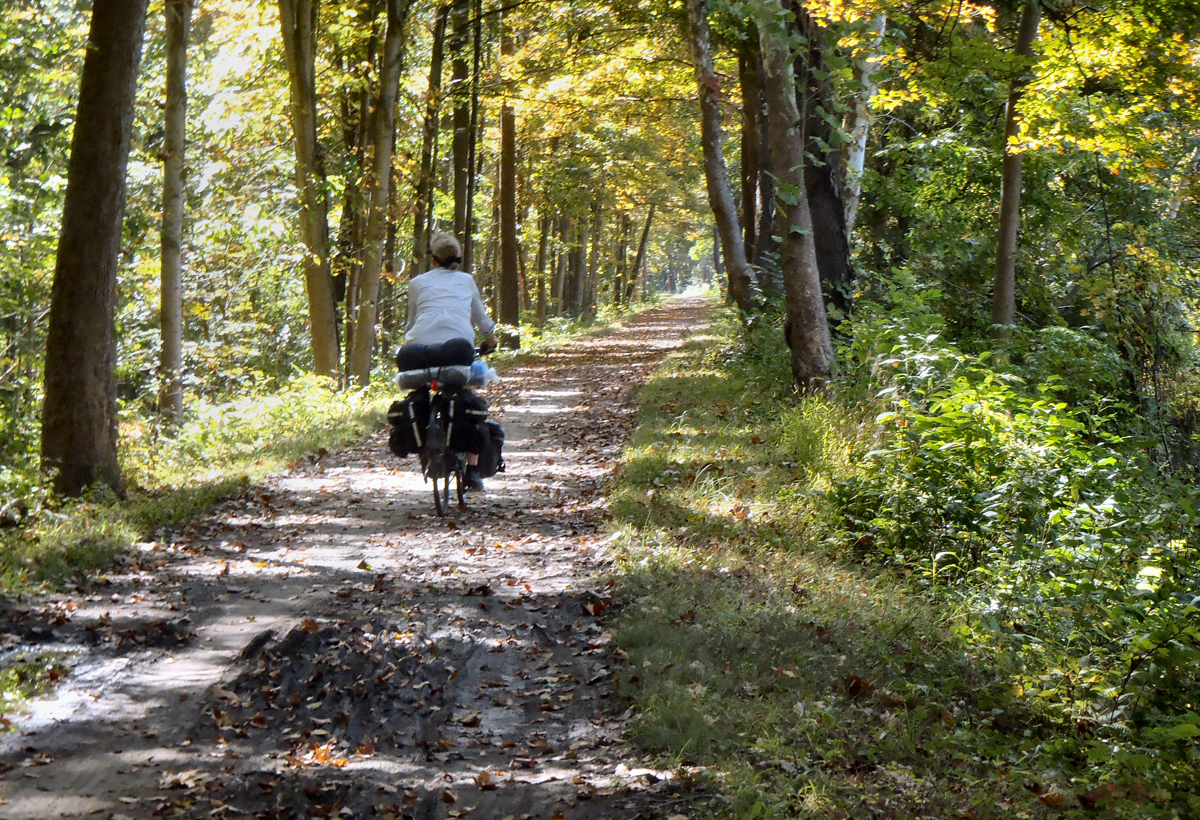
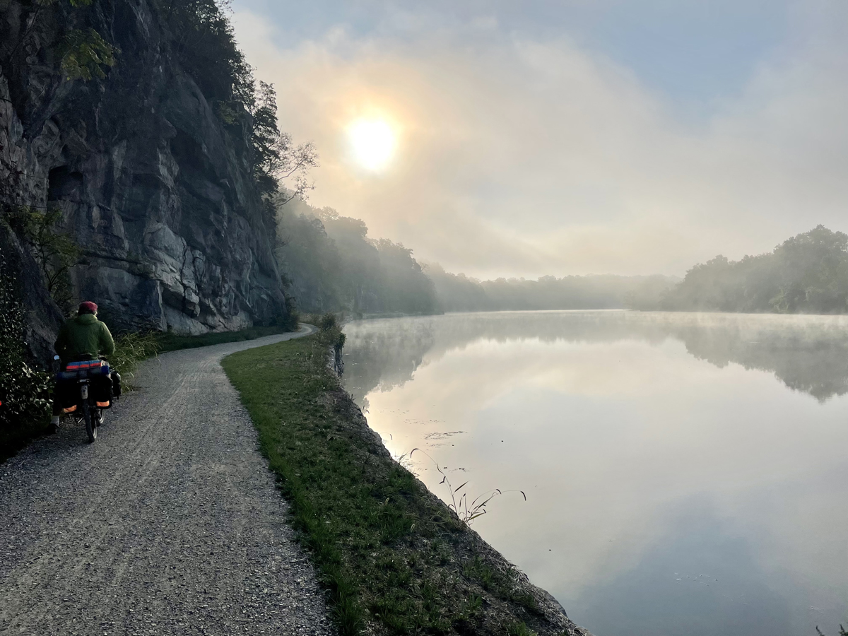
The towpath itself was a pleasure to ride. It is essentially level, as one would expect with a path that follows a canal and that was originally established by the horses and mules that pulled the canal boats from lock to lock. The overall elevation change between D.C. and Cumberland is about 700 feet, with all of that change occurring in a series of gentle, 10-foot “bumps” at each of the locks. The towpath varies in width from a few narrow, single-track sections near the Cumberland-end of the pathway to well-maintained, 6-to-8 foot wide, crushed stone surfaces for the bulk of the route. For what it’s worth, my old Rockhopper and Roz’s ancient Trek 520 easily handled all portions of the path.
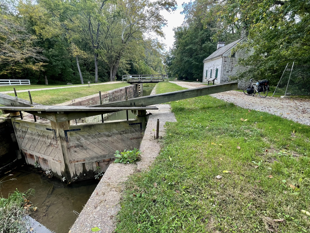
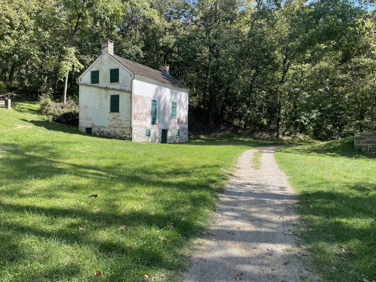
The structural remains of the original canal and its infrastructure are a constant presence as one rides along. In some places the canal is quite dry and in the process of being reclaimed by the surrounding forest. In many other places the canal has turned into a series of long ponds, filled with lily pads, turtles and water birds. In a few other stretches, where the Potomac had been dammed, the river itself was calm enough to be used as a portion of the canal route. There, the towpath literally hugs the edge of the river. Along the way we passed the remains of locks and aqueducts, and the simple stone houses that were built to house the lock-keepers who were on-call day and night to work the locks. Some of these features were no more than graceful stone ruins, and others looked as though they could be put back into service tomorrow. In fact, several of the lock houses have been refurbished and can be reserved for overnight stays. One highlight of the ride is the infamous Pawpaw Tunnel, a 3,000-foot-long hole that carries the canal through a stony ridge. It cost a great deal of time and money at the time, but it saved the canal-builders from having to build along several miles of especially twisty bends in the river.
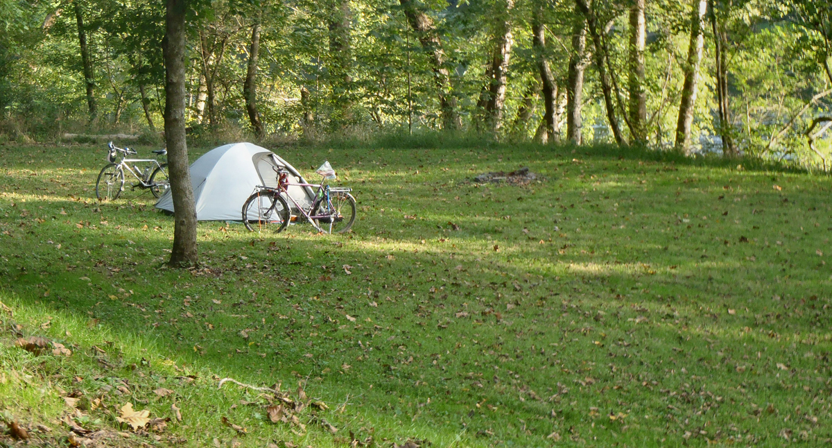
We like to camp out when we tour, and there were plenty of options for us as we rode the towpath. We used six of the 30 or so official hiker-biker sites that are maintained by the National Park Service. The campsites were free to use, and to our western, desert-oriented eyes seemed especially lush and luxurious. In general, each site consisted of a large patch of grass carved out of the surrounding forests. Each one was located between the towpath and the river, and contained one or more picnic tables, fire rings, a porta-potty, a hand-powered water pump, and a convenient trash-bag dispenser. The campsites (and the towpath itself) were remarkably free of trash and thoughtfully sited to take advantage of views of the river. The porta-potties were clearly maintained, but the water pumps were all labeled with signs saying that the water should be filtered or boiled before drinking (and me without a water filter!). Fortunately, drinkable water was easily found in the towns we passed along the way. Because we were traveling during a sort of off-season, we had several campsites all to ourselves, but we spent several lively nights at sites we shared with two to five other groups of travelers. We imagined that most of the sites would have been filled to the brim each night during the busy summer season.
The C & O Towpath passes through a number of small communities as it winds its way along the edge of the river. Some were founded to serve the needs of the canal, but most were much older farming or trading towns, with long histories and buildings that predated the American Revolution. We visited Harper’s Ferry, which was the site of John Brown’s final stand against the evils of slavery, and Shepherdstown, a tiny college town that claimed to be the oldest in West Virginia. Whatever a community’s origins, most seem to have recognized the benefits of being close to a well-used recreational pathway and have developed services designed to meet the needs of folks traveling the towpath. Despite the lateness of the season, we were always able to find supplies when we needed them, and every merchant we met was helpful and eager to please.
Like many of the trails that have been developed from disused railroad corridors, the C & O Towpath does suffer somewhat from the “tunnel effect” that results when the greenery alongside the trail is allowed to grow out and up over the pathway. The towpath was curvier than a typical rail bed might be, and it wasn’t a problem for us as there seemed to be so many interesting things to see. There are lots of breaks in the scenery where the towpath opens up onto the river or onto fields and pastures or rocky bluffs on the inland side of the canal, and when the pathway passes through towns. What was very appealing to us was the fact that there are only a handful of spots where the towpath interacts with motorized traffic. Though we passed under the occasional highway or railroad bridge, we found it easy to feel we were miles away from the hubbub of the modern world. We were especially impressed by how gently the towpath brought us into Washington. As we were pedaling the path in the late afternoon of the fourth day, we noticed that we were sharing it with an increasing number of pedestrians, runners and bike commuters. We were just a mile or so from the canal’s starting point when we suddenly found ourselves smack in the middle of Georgetown and a few short blocks from our hotel. The towpath allowed us to bypass altogether the suburban sprawl that surrounds the city.
Many of the riders we met were riding the C & O Canal Towpath as one leg of a longer tour that included a trail called the Greater Allegheny Passage (GAP). The GAP is a well-established rail-trail that links Cumberland and Pittsburgh, Pennsylvania and adds another 150 miles to the tour. The GAP connects directly, and conveniently, to the C & O Towpath in downtown Cumberland. Bicyclists ride the combined routes in both directions. Many riders said they had initially arrived in either D.C. or Pittsburgh with their gear and plans to shuttle back to where they started via Amtrak, which provides regular, bike-friendly service between the three cities. Others said they had rented their bikes and bags from one of the many outfits that cater to riders (and that provide shuttle service between cities). The bike tourists we encountered ranged from fast-moving bike-packers, traveling light and determined to put on the miles, to easy-going novices who preferred to end their daily rides in the comfort of one of the many B & B’s located in the communities along the route. We saw lots of riders who were out for a day ride or a single overnight, and a few long-distance tourists for whom the C & O Towpath and GAP were merely sections of much longer trips. We met a well-organized family of six riding the towpath from Pittsburgh to D.C. as a fun-filled learning experience for their home-schooled kids, and an older couple working their way down from New England and aiming for South America. Regardless of the level of experience of each rider we met, and despite the occasional trials and tribulations that are part of any truly memorable bicycle tour, everyone seemed to be having a really good time!
Trip Notes:
- There’s a 26-mile rail-trail that parallels the canal path on either end of the town of Hancock. It’s called the Western Maryland Rail Trail (WMRT). It is paved and would be a less-messy alternative to the towpath on a rainy day, but a section of it puts the rider in close proximity to a noisy section of interstate.
- We use a traditional front-and-rear pannier set-up to carry all our gear. We each carried two frame-mounted water bottles, plus two additional liter bottles in our bags for evening and morning use. In addition to all our camping supplies we each had good rain gear with us, and fenders were very handy when the trail got sloppy coming out of D.C.
- To get to our starting point, Roz and I chose to drive across the country carrying all our gear. It added another ten days of travel to our adventure, but we had the time and were able to visit friends and see new sights along the way. We live in Salt Lake City and are dedicated, life-long bike commuters, and together we have over a hundred bike tours under our belts.
- C&O Canal Towpath information: https://www.canaltrust.org/plan/co-canal-towpath


