Vegas, baby! When winter settles in to northern and central Utah, it is a fine time to head south. Utah’s warm-weather winter playground begins in the southern part of the State, and extends southward into Nevada, and perhaps southeastward into Arizona. The Las Vegas area has grown at astronomical rates over the past few decades, with urbanization gobbling up previously undeveloped land. Fortunately, the sprawl has extended only so far, leaving the parks, conservation areas, and recreational spots on the Vegas perimeter in their natural state. These areas are where the best road riding is located. One of the most popular rides in town travels through Red Rock Canyon, a National Conservation Area (NCA) – whatever that is (why not just make it a National Park?) – on the western edge of the Vegas valley. On weekends, you are likely to see a steady stream of cyclists making their out and back along Red Rock Canyon and Blue Diamond Roads. The canyon is far away from the Las Vegas Strip, and the glitz and maddening crowds, offering the visitor an entirely different experience.
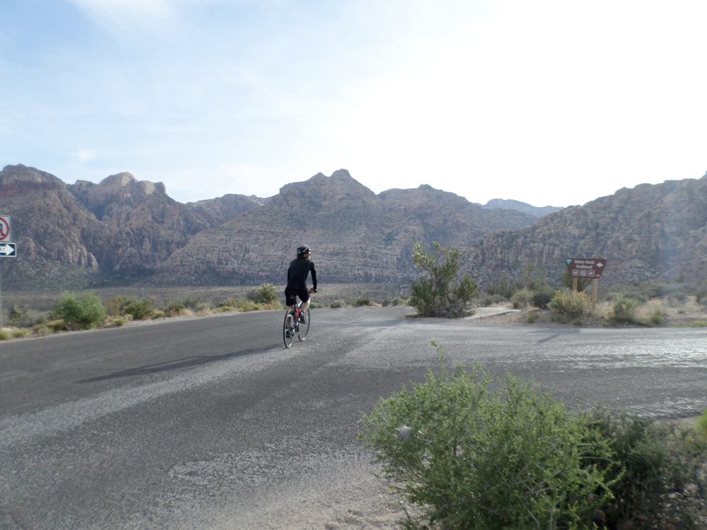
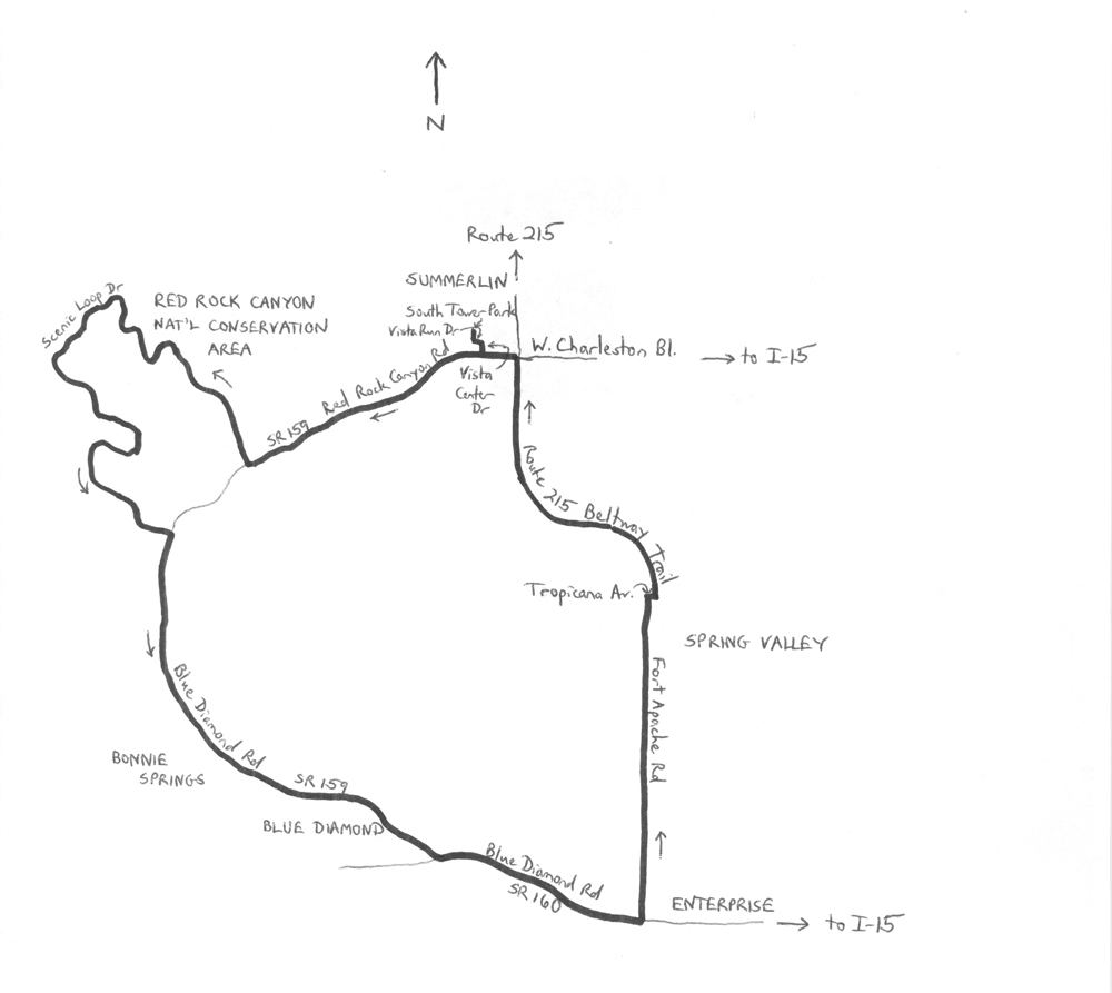
The Red Rock Canyon Cruise is a 43.7-mile counterclockwise loop through Red Rock Canyon National Conservation Area, and the communities of Blue Diamond and Summerlin. Elevations range from 2,571 feet in Summerlin to 4,774 feet in Red Rock Canyon. Most of the climbing and descending is long and gradual. Always take plenty of liquids with you when riding in the Las Vegas area. Start the ride in Summerlin, at South Tower Park, which is located at 1022 Park Vista Drive. The GPS coordinates are 36.162031oN 115.345844oW. Summerlin is a master-planned community (not part of the city of Las Vegas) developed by the Howard Hughes Corporation. The population was about 100,000 in 2010, and still growing! Head south on Park Vista, and make a left onto Vista Run Drive. Bear right at the traffic circle onto Vista Center Drive. Turn right onto Charleston Boulevard, which is State Highway 159, and head west. Out here, you are effectively at the western edge of development in the Vegas valley, and very quickly enter the Red Rock Canyon environs. The desert landscape is dry and bleak – until you look more closely. Red Rock Canyon Road, on which you are now riding, climbs gradually. At mile 5.1, turn right onto Scenic Drive. This is an optional but highly recommended loop, in which it is possible to see some of Red Rock Canyon’s plants and wildlife. Plants include the Joshua tree, Mojave and banana yucca, Creosote bush, and beavertail cactus, among others. Wildlife include bighorn sheep, wild horses, and desert tortoise. The star attraction, however, is the geology. The Keystone thrust fault has lifted a crustal plate over some younger rock, creating a stunning display of rugged colors. The older, gray carbonate mineral rock overlays younger tan and red sandstone. As the lighting changes, the colors range from brilliant to vivid. Although the Scenic Loop has a fee ($3 for bicycles), and is closed at dusk, it is certainly worthwhile. Once past the entrance station, turn right onto the drive (that is, do not head to the Visitor Center). The loop itself offers a few challenges, including a few short, steep climbs and descents. The highest elevation of the ride (4,774 feet) is along the loop. The road is one way, so there is no need to worry about oncoming traffic.
Exit the loop at mile 17.7, 2.2 miles downstream of where you entered the loop, and turn right onto Blue Diamond Road. The road, which continues State Highway 159, features a wide shoulder. There is a cattle guard shortly after the turn. Continue past enticing scenery and turnoffs, such as those to Spring Mountain Ranch State Park and Bonnie Springs (tourist-oriented Western-theme town). Leave Red Rock Canyon NCA at mile 22.3, and then, after another cattle guard, leave the canyon environment altogether at mile 25.3. The road skirts the edge of the small community of Blue Diamond (population 290 in 2010). Turn left onto State Route 160 at mile 26.8 – you are still on Blue Diamond Road. This is a wide, fast and gradually downhill highway with a good shoulder. Enter the community of Enterprise, which had a rapidly-growing population of 108,481 in 2010. Enterprise is the home of Allegiant Air. Look for Fort Apache Road after 3.5 miles on the highway. Turn left here and head north. The expansion of Las Vegas is evident out here, as you are bound to see a collection of houses under construction. The road itself may be under construction, as well (it was being widened when I rode it during the spring of 2014).
After crossing Warm Springs Road, enter the community of Spring Valley, which had a growing population of 178,395 in 2010. Spring Valley is known as the home of tennis pros Andre Agassi and Steffi Graf, and comedian Carrot Top. After a few more traffic signals, turn right onto Tropicana Avenue, at mile 38.0. After just one-tenth of a mile, carefully cross over Tropicana to access the I-215 West Beltway Trail. This is a 5-mile long bike path that parallels the freeway (which is actually not an Interstate freeway, but a County route, also known as the Bruce Woodbury Beltway). The bike path climbs gradually from 2,600 to just under 3,100 feet of elevation. Although there is not much to look at out here, except for the freeway, you should be able to see the uplifts of Red Rock Canyon to your left, and the Las Vegas skyline to your right. At Charleston Boulevard, carefully cross the road, and turn left. Turn right at Vista Center Drive, followed by a left at the traffic circle – be careful navigating this – onto Vista Run Drive. Finally, turn right onto Park Vista Drive to conclude the ride, at South Tower Park.
For more rides, see Road Biking Utah (Falcon Guides), written by avid cyclist Wayne Cottrell. Road Biking Utah features descriptions of 40 road bike rides in Utah. The ride lengths range from 14 to 106 miles, and the book’s coverage is statewide: from Wendover to Vernal, and from Bear Lake to St. George to Bluff. Each ride description features information about the suggested start-finish location, length, mileposts, terrain, traffic conditions and, most importantly, sights. The text is rich in detail about each route, including history, folklore, flora, fauna and, of course, scenery.
Wayne Cottrell is a former Utah resident who conducted extensive research while living here – and even after moving – to develop the content for the book.



Seems to me that what had been Bonnie Springs had been sold to a developer, so it’s no longer a tourist-oriented Western Theme Town. Sad, sad. When the founder (Bonnie Levinson) died, her heirs sold that formerly charming place to a developer. As this article points out, there are still many points of interest in the RRNCA.
Comments are closed.