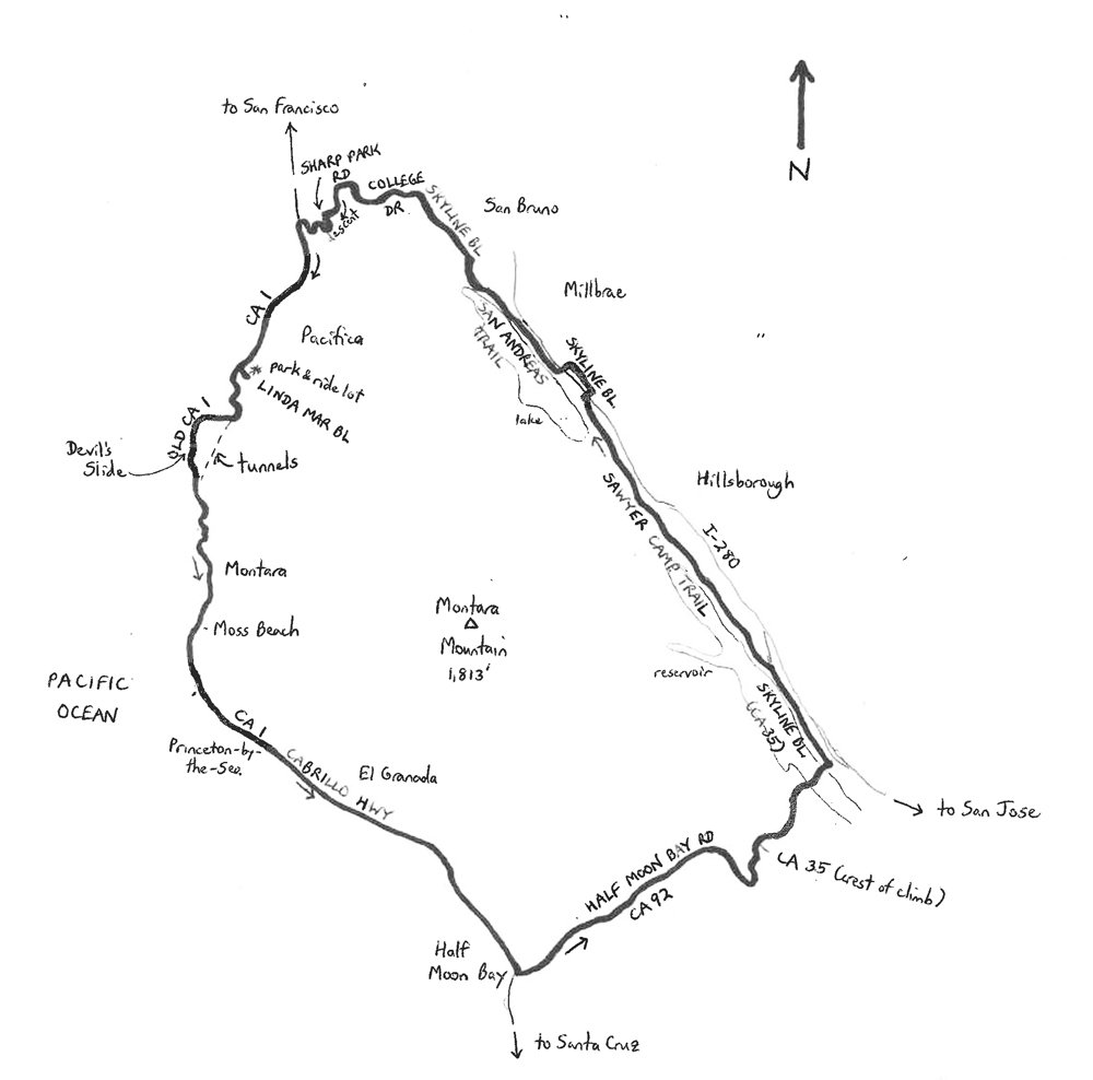
The Circuito de Montagna Montara is 36.6-mile, giant counterclockwise loop around Montara Mountain in northwestern San Mateo County, near San Francisco, California. The ride is one of several featured routes in my Best Bike Rides San Francisco (part of the Falcon Guides series). Montara Mountain is the most prominent peak in the northern part of the Santa Cruz Mountains, which stretch from north to south along the peninsula south of San Francisco. The high point (peak) is at 1,898 feet above sea level. There are no paved roads over the summit, so the Circuito hugs the mountain as closely as possible on good through roads and highways. The preferred direction is counterclockwise, to keep the Pacific Ocean on your right. Elevations along the ride range from just 3 feet, at the starting point, to 858 feet at the crest of the San Andreas Fault uplift (please see below).
The ride begins near the southern city limit of Pacifica, along California’s State Highway 1 (CA 1; also known as the Cabrillo Highway). Pacifica stretches along the coastline for six miles and inland for some distance up valleys that reach downslope from the Santa Cruz Mountains. The city is rich in takeoff points for surfing, hiking, mountain biking, fishing, and even skateboarding. Many summer days (June through August) find the city enshrouded in fog, with it occasionally lasting for days. Yet, the number of sunny days, during the rest of the year, is greater than the national average.
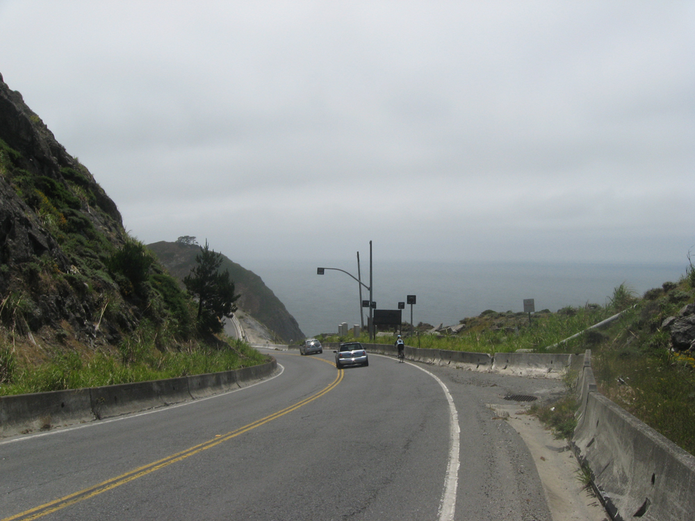
Begin the ride at the park-and-ride lot near the corner of CA 1 and Linda Mar Boulevard. Turn left and head south on CA 1. The highway immediately leaves the city and climbs into the forested hillside on the northwest slopes of Montara Mountain. The highway shoulder is narrow, but drivers are (or at least should be) used to seeing bicycles along this stretch. New to this stretch are the Tom Lantos Tunnels, through which the main CA 1 highway passes, leaving the old CA 1 to hikers, runners – and cyclists! After cresting, the old highway curves and begins a downhill along the rugged Pacific coastline. This is one of the more dramatic stretches of the highway, as it passes high above the crashing surf below, including Devil’s Slide. This stretch hovers above slopes that descend into the surf at gradients of 30% to 70%. Planning for the Lantos Tunnels, in fact, began way back in 1958. CA 1 was completed in 1937, but had been subject to cracking and landslides ever since – these actually closed the highway for up to months at a time, about every ten years. In truth, CA 1 has been gradually creeping toward the ocean since construction, with the movement accelerated after major rainstorms. The tunnels were finally opened to traffic in 2013, making the drive much safer for motorists. As for cyclists – well, consider it part of the adventure that the road may slide into the ocean, taking you with it.
Just south of the tunnel portal (i.e., the other end) is an unpaved parking area for Gray Whale Cove State Beach and McNee Ranch State Park. You may have noticed, on your right, some odd-looking militaristic construction. Six structures were built at Devil’s Slide during World War II to observe naval activity on the Pacific, as a means of protecting San Francisco. The observation structures were essentially steel-and-concrete pillboxes, a few of which still remain. As you leave this dramatic segment, CA 1 turns slightly inland and enters a series of unincorporated communities. These include, from north to south, Montara, Moss Beach, El Granada, and Princeton-by-the-Sea. Montara features Montara State Beach, which is a popular, mile-long beach. Potentially high surf during storm surges makes the beach unsafe for swimming, but very popular with expert surfers. To the south of Montara is Moss Beach, which features the Fitzgerald Marine Reserve, Moss Beach Distillery, and Seal Cove Inn (which is right along CA 1). The latter is a high-profile destination property.
El Granada’s concentric, circular street pattern was designed by famous city planner Daniel Burnham. The community was originally developed by Ocean Shore Railroad as a seaside resort for San Franciscans. Construction of the Ocean Shore Railroad between San Francisco and Santa Cruz started in 1905, with the northern portion extending as far south as Tunitas Creek, south of Half Moon Bay. The railroad used a coastal alignment, portions of which have long since been covered by landslides. Many of the railroad’s stations still exist, though, in some places they are private residences. In the meantime, El Granada has transformed into a sleepy coastal residential community.
The next community, Princeton-by-the-Sea, boasts the Half Moon Bay Airport, which is immediately adjacent to CA 1. This small community also hosts Mavericks, a surfing competition at Pillar Point Harbor that attracts experts who can handle the 50-foot waves. Just south of Princeton-by-the-Sea, CA 1 enters Half Moon Bay, the lone incorporated community along this stretch of highway. The coastal microclimate makes the entire stretch of CA 1 communities and the adjacent foothills subject to a greater amount of moisture than to the north or east. Annual rainfall of 50 inches is common, as is plenty of fog drip on overcast days.
Prepare to make a left turn at the city’s busiest intersection, CA 92, by checking for traffic and moving toward the left-turn lanes. Turn left with the signal onto CA 92 and head east. After a brief passage along the edge of the city’s central business district, which is to your right, continue to head out of town. CA 92 carries in excess of 20,000 motor vehicles per day, even as the highway narrows to just two lanes, so expect to share the road. The shoulder is narrow along the nearly imperceptible incline east of Half Moon Bay, so be attentive. After passing a number of nurseries, CA 92 finally widens as it approaches the second significant climb of this route. You are greeted by a wider shoulder and a stiff climb to the crest of an uplift that was caused by action along the San Andreas Fault.
CA 92 crests at Skyline Boulevard (CA 35) and then descends swiftly, adjacent to a dense grove of California oak woodland. The descent takes you down the drier side of the Santa Cruz Mountains, and once you are beyond the woodland the difference from the wetter, Half Moon Bay side is clear. The highway descends into the rift valley and crosses between the Lower (to the left) and Upper (to the right) Crystal Springs Reservoirs. Both reservoirs are artificial (the water is real) and are linked hydraulically. Water comes from local precipitation, the Hetch Hetchy Reservoir in the Yosemite Valley, and nearby watersheds. At the signal on the climb following the crossing of the reservoirs, turn left. You are now on the northern portion of Skyline Boulevard (CA 35). Ride north, with the I-280 freeway on your right and Lower Crystal Springs Reservoir on your left. The road climbs through here, cresting at Bunker Hill Drive, and then descends. Adjacent to the Crystal Springs Road intersection, turn left to enter the Sawyer Camp Trail.
Sawyer Camp is a paved trail that runs parallel to the northern arm of the reservoir for a distance. The trail began as an access road to Leander Sawyer’s camp in the mid-19th century, near the Jepson Laurel tree (600 years old, and the largest such tree in California). Later the trail was used by a stagecoach line from Millbrae to the north. Still later the trail became San Andreas Valley Road, along the main route between San Francisco and Half Moon Bay. Fast forward about 100 years, and with improved highways better serving motor vehicle traffic, the trail has become a destination path for nonmotorized vehicle users. The trail is six miles long, stretching from Crystal Springs Road in the south to Hillcrest Boulevard in the north, on the western edge of Millbrae.
Enjoy the Sawyer Camp Trail as it scoots along the rift valley adjacent to the Crystal Springs Golf Course. The Jepson Laurel is on the left, to the north of the northern end of Lower Crystal Springs Reservoir. The gradients are moderate, and there are bound to be plenty of path users. At the south end of San Andreas Lake, the path turns sharply to the right to cross San Andreas Dam. Similarly to the Crystal Springs Reservoirs, San Andreas Lake is a water source and is not open to the public. The lake rests directly on the San Andreas Fault. The path curves around the southern end of the lake and then climbs to a bench on the lake’s eastern side. Pay attention to the signs, as speed limits and the center-line rule are enforced along here. In fact, beyond the crest cyclists are cautioned to walk their bikes along the downhill to avoid conflicts with other path users. At the end of the path, to stay on pavement, turn right into the cul-de-sac (Hillcrest Boulevard), ride under I-280, and then turn left onto Skyline Boulevard.
At the next major intersection, which is Larkspur Drive, turn left, ride under I-280 again, and then turn right at the end of the street onto the San Andreas Trail. This is another paved path that is more or less a continuation of Sawyer Camp Trail. The path parallels San Andreas Lake on the left and Skyline Boulevard on the right until it ends at San Bruno Avenue. As you ride along, look upward to your left to view Sweeney Ridge. On November 4, 1769, the Gaspar de Portola Expedition sighted San Francisco Bay from high atop the ridge, thereby “discovering” it. At trail’s end at San Bruno Avenue, cross over to the other side of Skyline and continue heading north on Skyline. The road descends through here, and you will probably build up some good speed. The fun ends at Sneath Lane as Skyline levels and then starts to climb gradually as you enter the city of San Bruno.
Turn left onto College Drive (move into the left-turn lane) and begin the climb up to Skyline College. Follow the road as its curves to the left, entering the campus. The road, in fact, ends at a cul-de-sac through which bicyclists can pass. Follow the path through to the other side, continuing to climb. Turn right at the stop sign onto Ysabel Drive and descend away from the college. Turn left onto Sharp Park Road at the signal, immediately opposite Milagra Ridge County Park. Sharp Park Road descends sharply, twisting and plummeting toward the ocean. Watch your speed in the turns. After crossing over CA 1, turn left to ride along the frontage road, which is Bradford Way. Follow this bumpy road as it curves into a residential neighborhood (you are now in Pacifica). Continue to the T-intersection at Mori Point Road and turn left next to the Loyal Order of Moose facility (no actual moose).
Head up the short climb on Mori Point Road to CA 1 and turn right. Here you have two options: ride along the shoulder of the highway or take the parallel paved path. The paved path is actually more challenging than the highway, as it traverses hillier terrain. Both routes lead to the same place: southern Pacifica. Also, both routes involve two short climbs. The second one is especially dramatic, as a spectacular view of Pacifica State Beach is revealed over the crest. Also known as Linda Mar Beach, this is a popular spot for beginning surfers. Beginners can perhaps become experts very quickly here, as there have been a number of reports of white sharks in the waters over the years. Continue to Linda Mar Boulevard and turn left to conclude the ride, at the park-and-ride lot.
Starting & ending point coordinates: 37.595603oN 122.503103oW
For more Utah rides, see Road Biking Utah (Falcon Guides), written by avid cyclist Wayne Cottrell. Road Biking Utah features descriptions of 40 road bike rides in Utah. The ride lengths range from 14 to 106 miles, and the book’s coverage is statewide: from Wendover to Vernal, and from Bear Lake to St. George to Bluff. Each ride description features information about the suggested start-finish location, length, mileposts, terrain, traffic conditions and, most importantly, sights. The text is rich in detail about each route, including history, folklore, flora, fauna and, of course, scenery.
Wayne Cottrell is a former Utah resident who conducted extensive research while living here – and even after moving – to develop the content for the book.

