By Wayne Cottrell
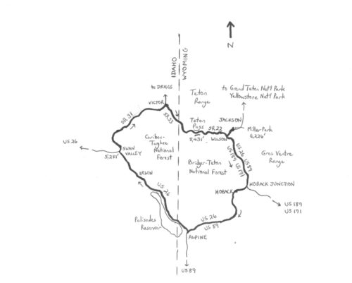
When summer’s heat starts to blanket most of Utah, a great escape is to head north to the milder temperatures of southwestern Wyoming, and southeastern Idaho. The Jackson Hole-Tetons Classic – known locally as “Around the Block” is a 109.2-mile loop through Jackson Hole Valley in Wyoming and Swan Valley in Idaho, and featuring a crossing of Teton Pass along the Idaho-Wyoming border. The entire ride is at over 5,200 feet altitude, with a lofty peak of 8,431 feet (Teton Pass). Be sure to check the weather and highway conditions before venturing out; the summer months are the best time of year for the ride. Old Pass Road to Teton Pass, for example, may not be open for riding until well into May. The main highway over the pass may be closed periodically during the snow seasons for avalanche control.
If ridden in a clockwise direction, then the Jackson Hole-Tetons Classic is net downhill for the first 64 miles, followed by gradual to arduous climbing for the next 33 miles, and concluding with a screaming descent and false flat for the final 12 miles. The low elevation is 5,281 feet in Swan Valley, Idaho, and the peak elevation is 8,431 feet over Teton Pass. This is a long ride, so be sure to dress appropriately and carry provisions with you, and be prepared to refill in one of the several communities through which you will pass along the way.
Start the ride in Miller Park, in the heart of Jackson. This thriving, small town surpassed the 10,000 population mark earlier this decade. Jackson is a popular gateway to the Teton Range and Grand Teton National Park, which are nearby, as well as Yellowstone National Park, which can be entered about 60 miles to the north. Jackson has its own airport; otherwise, it is a 279-mile drive northeastward from Salt Lake City. Alternatively, you can join over 1,500 other cyclists and bike from Logan to Jackson in the annual LoToJa Classic! It is a 206-mile ride that is held every September; the route described here covers a portion of the LoToJa course. Besides being a gateway city, Jackson is known for preserving its historical resources, such as buildings dating from the 19th century which are still found in the Town Square area. Jackson is also known for having the first all-female city council (1920), as well as a nearby ski resort (Jackson Hole) that has one of the steepest drops in North America (4,139 feet). The LoToJa Classic is the longest one-day bike race sanctioned by USA Cycling. The National Museum of Wildlife Art is here, as is the nearby National Elk Refuge. The summer-long Grand Teton Music Festival features near-nightly classical music concerts.
From Miller Park, which is at an elevation of 6,224 feet, head south on Jackson Street. Turn right onto West Broadway and head west. West Broadway is quadruple-signed as U.S. Highways 26, 89, 189 and 191, thereby confirming that Jackson is a major crossroads. Mountains of the Teton Range tower to your right. Cross Flat Creek 2.4 miles into the ride; shortly after the crossing, look to the right for the Paul Merritt Pathway. This paved path runs parallel to the highway for the next 5 miles, offering an alternative to the road. To your left are the mountains of the Gros Ventre Range which are, in turn, part of the Bridger-Teton National Forest. At mile 7.6, the pathway ends and you are back on the road. Cross the Snake River at mile 8.2. Enter the community of Hoback, bearing right at Hoback Junction at mile 13.1. While riding through town, you may experience the aura of “Hoback Nation,” which is a home-grown philosophic spirit. You are heading southwestward once beyond Hoback Junction, now on doubly-signed U.S. Highways 26 and 89 (U.S. 189 and 191 diverged back at the junction). The highway parallels the Snake River along this stretch. Enter denser forestation around mile 17.5; there are numerous pullouts to Bridger-Teton National Forest spots. Leave Teton County, of which Jackson is the county seat, at mile 21.6, and enter Lincoln County. The highway is gradually downhill as you ride adjacent to the course of the Snake River.
U.S. Highways 26 and 89 finally split at mile 35.9; bear right, onto U.S. 26, and enter Alpine (elevation 5,667 feet). This town of population 828 (2010) is a popular spot for snowmobiling, backcountry skiing, and hunting – and cycling, of course. Just to the north of Alpine is Palisades Reservoir, which will be on your left. Also nearby is the Idaho state line, which you cross at mile 38.3. The highway undulates over the next 8 miles, with a couple of climbs. After crossing the Palisades Dam, at mile 49.4, U.S. 26 continues its gradual descent. Enter Palisades at mile 54.3, followed by Irwin at mile 59.8, and then Swan Valley at mile 63.5. Turn right onto State Route (SR) 31, also known as Pine Creek Road, at mile 63.8, and head northeast. This is the low point of the ride (elevation 5,281 feet). Stay right at the split at mile 68.5, and enter Caribou-Targhee National Forest. Although you are on a long, gradual upgrade, the outstanding scenery is distracting. Leave Bonneville County at mile 78.0, now at an elevation of 6,777 feet, and enter Teton County (Idaho, not Wyoming). The highway descends into Teton Valley, entering the city of Victor. The population of Victor has nearly tripled since 2000 (1,928 as of 2010), and the city is now considered to be a suburb of Jackson.
Although, on a bicycle, with about 25 miles to go – including a mountain pass – you may feel as if you are nowhere near Jackson. Cross Main Street (SR 33) at mile 84.8, and then turn right onto North Agate Avenue at the next intersection (elevation 6,226 feet). This road heads south, and then curves to the left, becoming Old Jackson Highway. This is a quiet alternative to SR 33 for the next few miles. Junction with SR 33 at mile 88.8; turn left here and continue heading southeastward. Enter Wyoming at mile 90.4 (elevation 6,715 feet) – you are now on Teton Pass Highway, which is Wyoming’s SR 22, in Wyoming’s Teton County. The climbing starts at a 5% grade, increasing to nearly 9% after passing Coal Creek Meadows at mile 94.1 (elevation 7,243 feet). You finally reach Teton Pass at mile 96.8.
 The descent from Teton Pass is rapid, as the highway drops over 2,000 feet at a 9% grade in just 4.5 miles. For an alternative to the highway, Old Pass Road can be used. This is a paved path, not open to motor vehicles, that starts from the crest of Teton Pass (off to the right). Note that the road was being upgraded as of this writing, with a surface that was not as “healthy” as that of SR 22. Also, the road features numerous switchbacks and tight turns. Old Pass Road rejoins SR 22 where the highway grade eases, at mile 101.3. Beyond the base of the pass, SR 22 descends gently into a valley that is bound by Fish Creek on the west, and the Snake River on the east. In the heart of the valley is the community of Wilson, Wyoming (population 1,482 in 2010, elevation 6,148 feet). Wilson acts as a gateway to Teton Village, and as a portal to the finish line of the annual LoToJa Classic. After speeding across the valley, the highway climbs ever so gradually to a junction with U.S 189 and 191. Turn left here, and enter Jackson. Turn left onto Jackson Street to return to Miller Park. Congratulations are in order for completing such an awesome ride!
For more rides, see Road Biking Utah (Falcon Guides), written by avid cyclist Wayne Cottrell. Road Biking Utah features descriptions of 40 road bike rides in Utah. The ride lengths range from 14 to 106 miles, and the book’s coverage is statewide: from Wendover to Vernal, and from Bear Lake to St. George to Bluff. Each ride description features information about the suggested start-finish location, length, mileposts, terrain, traffic conditions and, most importantly, sights. The text is rich in detail about each route, including history, folklore, flora, fauna and, of course, scenery.
Wayne Cottrell is a former Utah resident who conducted extensive research while living here – and even after moving – to develop the content for the book.


