By Wayne Cottrell
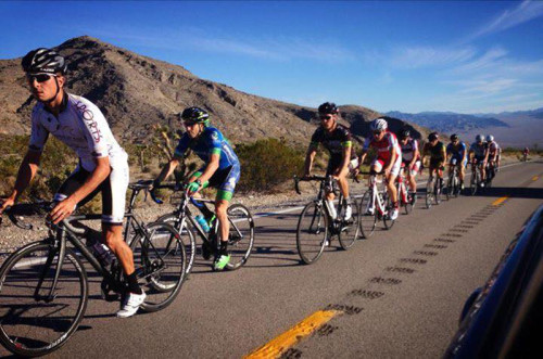
The Mount Charleston Challenge is a 60.4 mile ride that starts in the far northwestern corner of Las Vegas, Nevada, and heads westward and upward into the Spring Mountains. Mount Charleston towers over the Las Vegas Valley. Charleston Peak, which is the highest point of the mountain, reaches up to 11,918 feet, making it one of Nevada’s tallest. Mount Charleston, in fact, is one of the contiguous U.S.’ ten most prominent peaks, with a base-to-peak differential of 8,258 feet. The latter statistic suggests that anyone who starts from the bottom will not be saying “we’re here” for quite a long while of climbing! Mount Charleston is part of the Spring Mountains range that runs north-south to the west of Las Vegas. The peak is surrounding by the 43,000-acre Mount Charleston Wilderness, which in turn is surrounded by the Spring Mountains National Recreation Area, part of the Humboldt-Toiyabe National Forest, at elevations above 5,000 feet. And, the entire area is surrounded by the Red Rock Canyon National Conservation Area, which encompasses lower-elevation desert areas. Regarding the latter, Mount Charleston is a true oasis, offering a respite for desert dwellers looking to escape the heat and bustle of Las Vegas. Gateways to the mountain are located no more than 20 miles beyond the fringes of Las Vegas. Toward the summit, temperatures that are 20 to 30 degrees lower than in the desert, with plentiful snow during the winter months, await the traveler. Over one million visitors enjoy Mount Charleston’s recreational opportunities annually. On one Las Vegas visit, when the temperature was soaring above 100 degrees in the valley, I and a companion enjoyed a 5-mile hike near the summit in mid-70 degree weather.
For a cyclist, Mount Charleston represents one of the region’s top endeavors. A sub-80 minute ride time from bottom to top, during the annual Mount Charleston Hill Climb, is achieved only by well-trained, elite cyclists. The Mount Charleston Challenge, described here, extends the annual hill climb by turning the route into a loop, with an out-and-back segment, rather than a simple out-and-back only ride. The ride’s elevation differential is 5,969 feet, with a low elevation of 2,482 feet at the start-finish, and a high elevation of 8.451 feet along State Route 158 (Deer Creek Road) in the Mount Charleston Wilderness. Start the ride at Floyd Lamb Park, which is located at Tule Springs toward the far northwestern corner of Las Vegas. The official park address is 9200 Tule Springs Road (Las Vegas). Although this was once a State Park located outside of the city in a remote area, sprawl now places the park adjacent to residential areas, where there once was little but creosote and cactus. Floyd Lamb Park is home to several lakes, as well as the historic Tule Springs Ranch. Floyd Lamb was a Nevada state senator who famously accepted a bribe during an FBI sting operation. Despite the notoriety, and the serving of some jail time, Mr. Lamb did enough good for the park to retain his name. Parking inside the park was $6 as of this writing ($1 for bicycles, whether you park it or not). Given water’s scarcity in Las Vegas, be sure to take some time to explore the park’s lakes, as this a true oasis in the Mojave Desert.
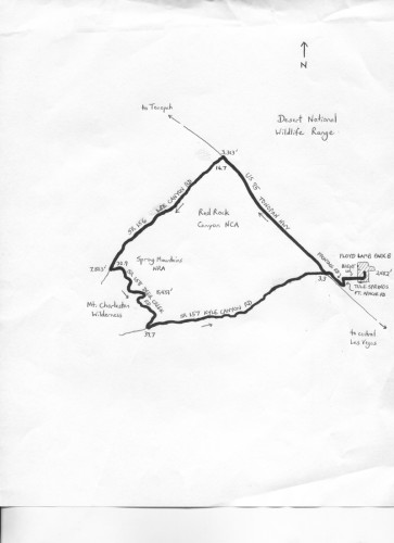
Exit the park via Tule Springs Road, which turns into Brent Lane at Durango Drive. Continue through the local residential area, and then turn left onto Fort Apache Road. After just 0.15 miles on Fort Apache, turn right onto Skypointe Drive (U.S. 95 frontage road), and head northwest. After 1.2 miles, look for Kyle Canyon Road on the left – there was no street sign when I went through here. Turn left here, and then turn right onto U.S. 95. This, the Tonopah Highway, scoots through the Las Vegas Valley, across the Mojave Desert, climbing gradually. This four-lane, 70-mph highway features a wide shoulder that has a rumble strip. Off to your far right is the Desert National Wildlife Refuge, the largest such refuge in the U.S. outside of Alaska. The range features an abundance of wildlife and endangered species. The highway passes under Paiute Road after a little over 3 miles; be cautious here. Corn Creek Road, a little over 9 miles along U.S. 95, provides access to the refuge. Finally, turn left, after 13.4 miles on U.S. 95, onto State Route 156 (Lee Canyon Road).
Lee Canyon Road climbs one of the eastern flanks of Mount Charleston, ascending steadily from 3,313 feet at U.S. 95 to 7,803 feet at the State Route 158 (Deer Creek Road) junction, over a distance of 14.2 miles. The average uphill grade is a steady 6%. The scenery transforms from Joshua trees and desert scrub to a near-alpine environment, with trees and forestation. Enter the Spring Mountains National Recreation Area at the 5,000-foot elevation mark, at mile 22.7. The trees, including low pines, begin to appear above 6,000 feet. A false crest provides some relief at Macks Canyon. Turn left at mile 30.9, onto State Route 158 (Deer Creek Road). The climbing continues as Deer Creek winds its way through the Mount Charleston Wilderness. As you ride above 8,000 feet, taller pine trees appear. The high point of the entire ride finally comes near the North Loop trailhead: 8,451 feet, nearly 6,000 feet higher than where the ride started.
After over 30 miles of climbing, the reward is the descent. Deer Creek Road initiates the plunge immediately, losing 1,629 feet over the next 4.7 miles (6.6% grade). Stop – if you can (just kidding; rumble strips in the road are there to slow everyone down) – and turn left onto State Route 157 (Kyle Canyon Road). The Resort on Mount Charleston, on the right, is a popular venue during the winter snow season. Kyle Canyon Road descends rapidly, losing just over 4,000 feet in 17.4 miles. The scenery on the descent is transformative, with the landscape becoming dry and craggy, with Joshua trees, desert scrub, and even a few hoodoos becoming dominant. After passing a few residences, stop at, and then carefully cross over U.S. 95. You have now completed the 53.8-mile Mount Charleston loop, and are on the return ride. Turn right onto Sky Pointe Drive, left onto Fort Apache Road, and then right onto Brent Lane. Follow Brent across Durango, and onto Tule Springs Road. Enter Floyd Lamb Park (at Tule Springs) to conclude the ride.
For local cycling information, visit
Broken Spoke Bikes
11700 W. Charleston Blvd. Las Vegas, NV 89135
702-823-1680, www.brokenspokebikeslv.com
For more rides, see Road Biking Utah (Falcon Guides), written by avid cyclist Wayne Cottrell. Road Biking Utah features descriptions of 40 road bike rides in Utah. The ride lengths range from 14 to 106 miles, and the book’s coverage is statewide: from Wendover to Vernal, and from Bear Lake to St. George to Bluff. Each ride description features information about the suggested start-finish location, length, mileposts, terrain, traffic conditions and, most importantly, sights. The text is rich in detail about each route, including history, folklore, flora, fauna and, of course, scenery.
Wayne Cottrell is a former Utah resident who conducted extensive research while living here – and even after moving – to develop the content for the book.





[…] to hit the slopes; during the warmer months, there’s plenty of hiking, climbing, and even cycling to get your daily activity […]
Comments are closed.