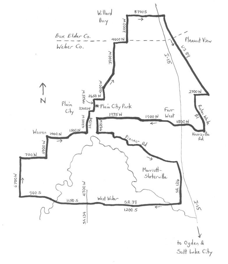
By Wayne Cottrell — Although Weber County’s population has grown by over 50% in the past 25 years, things tend to get quiet in the area west of I-15, to the northwest of Ogden. The North Weber Basin Ramble is a 33.8-mile ride on the roads in this area. The ride is nearly pancake flat, with an elevation differential of just 90 feet, and only one hill of any note. The heaviest traffic volumes were on roads having adequate shoulders. These included U.S. Highway 89 in Pleasant View (6,900 vehicles per day), 2700 North in Pleasant View (14,500 vehicles per day), and Rulon White Boulevard in Farr West (6,100 vehicles per day). The other roads in the ride have narrow shoulders, with the busiest being State Route (SR) 126, with 8,700 vehicles per day north of SR 39. Use caution on all roads having narrow shoulders. There are a few railroad crossings along the way, all of which had been improved (i.e., not the old, bumpy kind).

The ride passes through the cities of Farr West, Marriott-Slaterville, Plain City, and Pleasant View, as well as the unincorporated communities of Warren and West Weber. The route visits Box Elder County for a short stretch. Start the ride in Plain City, at Plain City Park, located at 2350 North and 4425 West. Plain City had a population of 5,887 in 2012. Settlement began in 1859, and was based on 1.25-acre lots. Head north on 4425 West. The road bends right at mile 0.4, becoming 2650 North. At the end of 2650 North, turn left and head north on 4200 West. After passing by a few residences, 4200 West bends to the right (mile 1.0), leaving the city. After crossing the Little Mountain Rail Trail, the road bends to the left, becoming 3900 West. It is a straight shot northward, as you ride along the fringes of the Willard Bay Wildlife Management Area (to the left). At the end of 3900 West, turn right onto 4000 North and head east. Next, turn left onto 2000 West (mile 3.35) and head north – enter Box Elder County. You are bound to see a few boaters and anglers, as the South Recreation Area of Willard Bay State Park is on the left. The road curves to the right at 8700 South, to head east. After passing under I-15, 8700 South climbs the only true hill of the ride (at a gentle 2.4% grade), to meet US 89.
Turn right onto US 89 and head southeast. The highway is one-way (in your direction!) for just under one mile. Return to Weber County at mile 7.05, entering Pleasant View, and reaching the highest elevation of the entire ride (4,308 feet). Pleasant View had a population of 8,340 in 2012, and is primarily a bedroom community. Turn right onto 2700 North (mile 9.4) and head west. Turn left onto Rulon White Boulevard (1500 West; mile 9.95) and head south. As this road serves an industrial area, it is lightly-used after hours. Rulon White served as Ogden’s mayor (1950-1951). Turn right onto Harrisville Road (mile 11.45) and enter Farr West. This city had a population of 6,122 in 2012, having doubled since 2000. Despite the geographical-sounding “Farr West,” the city’s name actually pays homage to Mormon (LDS) pioneers Lorin Farr (former president of the Weber LDS stake) and Chauncey W. West (former presiding bishop of Weber County). Harrisville Road curves to the right, becoming Farr West Drive, and then to the left, becoming 1800 North. Pass under I-15, and continue heading west. The road makes a couple of alignment shifts along the way. By the time you have re-entered Plain City, you are on 1975 North.
At 4425 West (mile 15.7), you have the option of bailing out of the ride by turning right and returning to Plain City Park. You are otherwise halfway through. For those who are game, turn left and head south on 4425 West. Next, turn left onto Pioneer Road and head east. Leave Plain City and enter the city of Marriott-Slaterville. This city, one of Utah’s newer ones (incorporated in 1999), had a population of 1,727 in 2012. A number of descendants of famous hotelier J. Willard Marriott reside here. Pioneer heads south southeast, with a couple of sharp right and left turns along the way. Turn right onto SR 126 and head south. At 1200 South (mile 21.4; SR 39), turn right and head west. Leave Marriott-Slaterville after crossing over the Weber River. Enter the community of West Weber; its population of several hundred was little different from its 1887 total of 700. Infrastructure improvements along SR 39 and westward as of this writing suggest that the area is preparing for growth, though, after some 125 years! SR 39 ends at 4700 West; the road continues as 1200 South, and then as 1150 South (and 900 South) after curving to cross the meandering Weber River again. Turn right at 6700 West (mile 27.55) and head north.
6700 West reaches the lowest elevation of the entire ride (4,218 feet), as you are just 12 feet above the surface elevation of the Great Salt Lake. Turn right onto 700 North and head east; at the end of this road, turn left onto 5900 West and head north. Next, turn right onto 1400 North and head east, entering the community of Warren. This settlement, named in honor of Lewis Warren Shurtliff (former local stake LDS president) is nearly seamless with Plain City, which you re-enter at 5200 West. The road jogs to the left and right, becoming 1500 North. Turn left at 4700 West (SR 134) and head north. The road passes by Fremont High School, which may be best-known as the alma-mater of David Hale, who played for two seasons with the NFL’s Baltimore Ravens. SR 134 turns right at 2200 North to head east. Next, leave SR 134 by turning left onto 4425 West. From here, it is two blocks to Plain City Park, and the end of the ride.
For more rides, see Road Biking Utah (Falcon Guides), written by avid cyclist Wayne Cottrell. Road Biking Utah features descriptions of 40 road bike rides in Utah. The ride lengths range from 14 to 106 miles, and the book’s coverage is statewide: from Wendover to Vernal, and from Bear Lake to St. George to Bluff. Each ride description features information about the suggested start-finish location, length, mileposts, terrain, traffic conditions and, most importantly, sights. The text is rich in detail about each route, including history, folklore, flora, fauna and, of course, scenery.
Wayne Cottrell is a former Utah resident who conducted extensive research while living here – and even after moving – to develop the content for the book.


