The corridor between Las Vegas and Los Angeles is one of the heaviest-traveled long-distance routes in the country. Most Vegas-L.A. travelers drive the route, using the I-15 freeway. Long before the speedy and sleek Interstate was built, though, travelers drove along the old, two-lane Las Vegas-Los Angeles highway, which today is parallel to I-15. Portions of the old highway still exist, and are ripe for bike riding. As for bicycling from Las Vegas to Los Angeles – if one were to attempt the 250-mile-or-so ride – the rider would actually head south from Vegas on U.S. Highway 95, toward Laughlin, and then junction to historic U.S. Route 66.
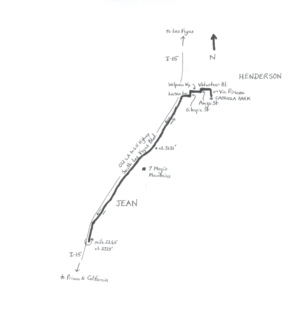
 Map of the Old Vegas-to-LA Highway Ride. Map by Wayne Cottrell
This ride does not follow that route, and won’t take you to Los Angeles, but it does follow the old Vegas to L.A. highway until the pavement literally ends. The 45.3-mile out-and-back ride is not particularly long, but the potential desert heat and dryness, along with some long, gradual climbs (just over 1,200 feet of total climbing), and maybe some wind, offer decent challenges to the cyclist. Although the scenery is marred somewhat by the constant presence of I-15, there are plenty of wonderful sights in the Las Vegas and Ivanpah Valleys.
Start the ride at Capriola Park (elevation 2,591 feet), located at 2155 Via Firenze in the city of Henderson, located about 10 miles southeast of central Las Vegas. To get to the park, head south on I-15 to the St. Rose Parkway, which is the southernmost Las Vegas Valley interchange. Head east on St. Rose, followed by a right turn onto South Las Vegas Boulevard, and then a left turn onto Volunteer Boulevard. At Via Firenze, turn right and head south – continue past Solista Park to Capriola Park. Henderson had a population of 285,667 in 2015, making it the second-largest city in Nevada. While Vegas has all of the glitz and glamor, Henderson is comparatively residential and quiet, with several planned communities. The city has been ranked as one of the safest places to live in the U.S. Henderson may be best known, however, for the 1988 PEPCON blast. The PEPCON plant produced ammonium perchlorate (AP), which was an oxidizer found in solid propellant rocket boosters, such as those used in the Space Shuttle. Because the Shuttle had been grounded, some 4,500 metric tons of AP were stored at the site. On May 4th, 1988, an industrial fire started, possibly caused by repairs that involved welding. The fire spread rapidly through fiberglass materials in the buildings, and AP residue. Once the stored AP ignited, a massive explosion occurred, followed by six smaller ones. The first explosion had the force of a kiloton of TNT, roughly the equivalent of a nuclear weapon. The smaller explosions produced earthquakes registering 3.0 and 3.5 on the Richter scale. There were two plant worker fatalities (the others had quickly evacuated), and numerous broken windows and damaged motor vehicles within a several-mile radius. The plant’s buildings, and a nearby factory, were leveled. A nearby moving vehicle was literally separated from its chassis by the blast, killing the driver.
Thankfully, little evidence remains of the disaster. PEPCON relocated to a site outside of Cedar City, Utah (where another explosion occurred in 1997). A university and auto dealerships now occupy the old site. With you perhaps thinking about blasting off on this bike ride, head north from the park on Via Firenze. Solista Trail (bike path), in the median of Via Firenze, is an alternative, but the path is not paved. After passing Solista Park, Via Firenze ends at Volunteer Boulevard. Turn left here and head west to friendly Amigo Street; here, turn left, 2.1 miles into the ride. Amigo bends to the right, becoming Welpman Way, at the lowest elevation of the ride (2,461 feet). At the end of Welpman, turn left onto Gilespie Street and head south. At Larson Street, turn right to head west once again. You reach the featured segment of the ride, South Las Vegas Boulevard, at mile 3.75. Turn left here and head south (no, not north to The Strip!). Las Vegas Boulevard leaves the Las Vegas Valley, climbing gradually across the mostly barren landscape. Although Henderson’s city limits stretch southward of here, there is little development, except for I-15. The last sign of civilization, other than some industrial operations, is the Speed Vegas racetrack, on your left at mile six. Yet, farther out and appearing out of nowhere, just off the road, are seven stacks of brightly-colored boulders, situated in the middle of the desert landscape. The outdoor artwork is entitled “Seven Magic Mountains,” the creation of Swiss artist Ugo Rondinone. The sculpture “opened” in May 2016 for a two-year display.
The high elevation of the ride (3,131 feet) comes at mile 10.65. From here, it is gradually downhill to Jean (elevation 2,846 feet, mile 18.65). Jean is a commercial town with no residential population, but with the striking Gold Strike Casino, post office, and other facilities. The former Nevada Landing Casino, on the opposite side of I-15 from the Gold Strike, was demolished several years ago. Jean Conservation Camp, on the slopes to the west of Jean, is a minimum-security women’s prison. In fact, in December 2015, a prisoner simply walked away – minimum security indeed! Continue past Jean, passing the Jean Aviation Center, which is used for skydiving. From here, you may be able to see Primm, off in the distance, on the California border. The paved road does not go all the way there, though, turning to dirt exactly four miles outside of Jean. Turn around here (mile 22.65, elevation 2,723 feet).
The return ride features a gradual climb of 408 feet, to the ride’s highest point (3,131 feet, at mile 34.65), followed by gradual descending (670 feet). Turn right onto Larson Street at mile 41.55 to continue the return ride to Henderson. After Welpman Way bends to the left, becoming Amigo Street, it is a gradual climb to the finish, at Capriola Park.
GPS coordinates (Capriola Park, Henderson): 35.944986oN 115.124500oW
For more rides, see Road Biking Utah, Best Bike Rides Los Angeles, and Best Bike Rides San Francisco (all from Falcon Guides), written by avid cyclist Wayne Cottrell. Each book features descriptions of approximately 40 road bike rides. The ride lengths range from 14 to 106 miles. Each ride description features information about the suggested start-finish location, length, mileposts, terrain, traffic conditions and, most importantly, sights. The text is rich in detail about each route, including history, folklore, flora, fauna and, of course, scenery.
Wayne Cottrell is a former Utah resident who conducted extensive research while living here – and even after moving – to develop the content for the book.


