By Wayne Cottrell
The Powder Mountain Challenge is a 39.1-mile out-and-back climbing challenge in Weber County. The route includes three strenuous climbs, the second of which ascends Powder Mountain. Although the name “Powder” might conjure notions of ‘powder puff,” as if the climb is soft and easy, it is far from that. In fact, Powder Mountain Road (State Highway 158) is considered to be one of the steepest roads in Utah, averaging a 14% gradient over a 5-mile stretch (with steeper pitches thrown in to augment the challenge). Please note that snow or ice can make this ride treacherous, so be sure to check the weather and the roads before venturing out.
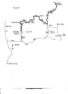
Ready? Alright – roll out from the Ogden Nature Center Nature Trailhead in Ogden, and head north on Mountain Road. The trailhead – an access point for the Bonneville Shoreline Trail – is located on Mountain Road just north of 1100 North, in Ogden. To access the trailhead, head north from Salt Lake City on the I-15 freeway. Exit at 12th Street (State Highway 39) and turn right. Turn left at Harrison Boulevard (State Highway 203) and head north. The road’s name changes to Mountain Road near 1100 North. Look for the trailhead (small, paved parking lot) on the right, just north of 1100 North. Mountain Road rolls into North Ogden almost immediately. Turn left onto 2600 North at mile 2.1. North Ogden – clearly a suburb of Ogden – had a population of 17,357 in 2010. The city’s population has nearly doubled since 1980. Towering over the city is one of the Ogden area’s signature peaks, Ben Lomond. The mountain’s top is at 9,712 feet. While the Wasatch Mountains form a north-south border along urban Utah, Ben Lomond appears to run east-west, thereby giving it prominence among the range’s other peaks. Déjà vu is common when gazing at Ben Lomond – the Paramount Pictures logo is said to be an image of the mountain.
 After a gradual descent of 2600 North, turn right onto 1050 East and climb the lower, developed slopes of Ben Lomond. This is the opening climb of this ride, and is a good opportunity to check your fitness. That is, if you are completely out of breath by the time you reach 3100 North (0.75 miles at a 4.7% grade), then you may want to consider bagging it, turning around, and trying this ride on another day. But, if the climb merely whet your appetite, then turn right onto 3100 North and head east. As you leave North Ogden’s residences, 3100 North becomes North Ogden Canyon Road. From an elevation of 4,775 feet at the 1050 East intersection, the road climbs – quite steeply along a few stretches – to 6,190 feet at the North Ogden Divide. The average gradient is 8.9% over 3 miles. From the North Ogden Divide, with Ben Lomond to your left and Lewis Peak (8,031 feet), North Ogden Canyon Road rapidly descends into Ogden Valley. The valley is abundant in recreational opportunities, with Wolf Mountain (skiing), Snowbasin (more skiing – 2002 Winter Olympic Games venue), Pineview Reservoir (water sports), and Powder Mountain (still more skiing), to which you are heading. North Ogden Canyon Road becomes 4100 North once you are on the valley floor. The “floor” is not flat, as the road rolls, descends and false-flats its way through the lightly-developed landscape.
Enter the community of Liberty around mile 9. Liberty had a population of 1,257 in 2010 – settled in 1869, it was separated from Eden, which is to the southeast, once growth began to occur. Turn right onto 3500 East (State Highway 162) once in Liberty and head south, and then southeast. The only four-way stop-controlled intersection for miles around is at mile 12.3. This is a crossroads, so to speak, with a market and convenience store adjacent. Stock up here, if necessary. Turn left onto State Highway 158 (also known as Powder Mountain Road) and head north toward Wolf Creek and Powder Mountain. Climbing begins after about one mile along this road, with the Wolf Creek Resort sprawling to your left and right. Wolf Creek is a large (3,000 acres) resort community with numerous amenities (golf, tennis, spa, access to skiing). After a false crest – shake your legs out here – climbing resumes at mile 14.5. From here, the gradient is relentless. Nope, there is no relief in sight, as the road climbs steadily and steeply over the next 6 miles to Powder Mountain. A sign indicates that the gradient is 16%. The sign is there to warn truck drivers, but is just as informative for inquisitive cyclists. As you climb into the rarefied air, you will notice that the flora changes from the smaller juniper and pinyon pine trees – quite common throughout Utah – to stately and majestic alpine trees, particularly evergreens.
After a sharp, 90o bend, and then a hairpin (180o) curve, the road climbs to Powder Mountain – where it abruptly ends (elevation 8,248 feet). You have just climbed 3,300 feet, and a total of 4,890 feet since the ride’s start. Turn around here, at mile 19.5, and return via the reverse route.
Vivid descriptions of Powder Mountain, the descent and return ride continue in the forthcoming edition of Road Biking Utah, Volume 2.


