By Wayne Cottrell
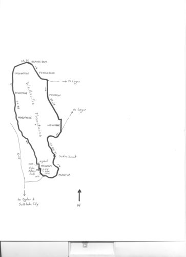
The Wellsville Mountains separate Cache County from Box Elder County in northern Utah. The highest point is Box Elder Peak, at 9,372 feet. The mountains are extremely steep, with an average gradient of 25% — steeper in places – and a prominence of nearly 5,000 feet. This 52.5-mile ride follows the perimeter of the mountains, passing up and over crests at the northern and southern ends of the range. No roads penetrate the mountains anyway, given their steepness.
The ride starts and finishes in Brigham City, and visits several cities, towns and communities along the way, including Honeyville, Deweyville, Collinston, Beaver Dam, Petersboro, Mendon, Wellsville, and Mantua. Most of the roads are lightly-traveled by motor vehicles. Shoulders are adequate along the busier segments, such as along U.S. Highway 89.
Although you may be awed by the Wellsvilles’ 5,000-foot prominence, the elevation differential of the ride is “only” 1,640 feet. With a safely-executed ride at a comfortable pace, your wellness should be enhanced by the end. (Although, note that Wellsville has little to do with “being well,” as it was named for Mormon pioneer settler Daniel H. Wells).
Brigham City is the seat of Box Elder County, serving as a gateway to far northern Utah, including Cache County. With a growing population of 18,454 in 2015, this is the largest city along the route. The city may be best known as the location of Brigham Young’s final sermon, in 1877.
The city is a launching point for some points of historical interest, including the Golden Spike National Historic Site, which is to the west northwest. There are also a number of historical sites within the city, such as the Box Elder Stake Tabernacle, and others that are concentrated around Main Street. The ride route avoids Main Street and the central part of the city, but a side trip is strongly encouraged.
Start the ride at John Adams Park in Brigham City, located at 600 East 100 North. Park on 500 East south of 100 North, within the park. Head north on 500 East; the starting elevation is 4,422 feet. The opening part of the ride is gradually downhill, through a residential area. At the end of 500 East, turn left onto Highland Boulevard. At the end of Highland, turn right onto State Route (SR) 38 (mile 1.25), and head north.
SR 38 leaves Brigham City, entering a long stretch of false flats and almost imperceptible elevation changes. The low elevation of the ride (4,256 feet) is reached at mile 5.3. Enter the city of Honeyville at mile 7.3 (population 1,421 in 2013); Call’s Fort Monument on the left is an unofficial gateway. A fort, on this site, was built in 1855 under the direction of Brigham Young, as a defense against Native Americans. Honeyville was originally established as a Bear River ferry crossing point, in the days before bridges.
Today, the city may be best known for the Crystal Hot Springs resort, on the left at mile 11.45. Just beyond the resort, which features hot and cold mineral springs, enter the town of Deweyville (population 333 in 2013). The town’s namesake, John C. Dewey, directed the construction of a schoolhouse and Sunday school, served as the town’s Postmaster, and was the bishop of the local church (LDS) ward!
Enter the community of Collinston around mile 19. Collinston may be best known for being near the point at which John C. Frémont crossed the Bear River during one of his famous 1840s’ expeditions. For you the cyclist, though, Collinston may be most memorable as the point at which SR 38 starts to climb gradually.
Leave Collinston and turn right onto SR 30 at mile 20.1, beginning a 3% grade climb to a false crest. Next, there is a short descent through the small community of Beaver Dam, and then a 3% climb to the crest of the passage along the northern flanks of the Wellsville Mountains. The crest, at 4,981 feet (mile 24.4), marks the entrance into Cache County.
From here, it is a speedy descent into Cache Valley. You may hardly notice coasting through the small community of Petersboro, also known as Peter, on the way down SR 30. The community’s population is nearly identical to that of Deweyville.
Turn right onto SR 23 at mile 27.5, and head south. This highway, like SR 38, features long, false flats and barely-noticeable elevation changes. Enter the city of Mendon at mile 29.6. This city, with a population of 1,315 in 2015, features a number of historical sites. While most of them are in town, to your left, a few are along the main highway (which is 100 West in the city).
These include the former Forster Hotel at 176 North, the George Washington Baker House at 115 North, the James G. Willie House at 97 North, and the William & Elizabeth Barrett Farmstead at 20 South. Continuing south on SR 23, enter the city of Wellsville (population 3,578 in 2014) at mile 35. The highway curves to the left, and then to the right (still heading south), becoming Center Street. Points of historical interest include the Wellsville Relief Society Meeting House at 67 South, and George Bradshaw House (and Barn) at 73 South.
Leave Wellsville, and turn right onto U.S. 89 (double-signed as U.S. 91) at mile 37.6. The highway has four lanes, and an adequate shoulder. Leave Cache Valley at mile 38.9, entering Wellsville Canyon. Thus begins the featured climb of the ride, at an average grade of 4.3%, to a false crest. After a short descent, the climb resumes, at a 4.0% grade, to Sardine Summit (elevation 5,896 feet). This is the highest elevation of the ride, and is the main gateway to Cache Valley, which is now behind you. The summit is at mile 44.5, with eight to go; it is all downhill from here to the finish.
The picturesque town of Mantua and Mantua Reservoir are on the left from mile 47.25. The town was originally settled by Danish immigrants; listen to how the residents pronounce the name of their town! And, be sure to use caution at the merge from the right, at mile 48.8 – this is where vehicles from Mantua enter the highway. Leave U.S. 89/91 at mile 50.55, via the exit ramp onto SR 90. Enter Brigham City as the road curves to the left; turn right onto 100 South, followed by a right turn onto 600 East. John Adams Park is on the left from 100 North, although you will return to the start by continuing north to 300 North, and turning left here, followed by a left turn onto 500 East to enter the park.
For more rides, see Road Biking Utah (Falcon Guides), written by avid cyclist Wayne Cottrell. Road Biking Utah features descriptions of 40 road bike rides in Utah. The ride lengths range from 14 to 106 miles, and the book’s coverage is statewide: from Wendover to Vernal, and from Bear Lake to St. George to Bluff. Each ride description features information about the suggested start-finish location, length, mileposts, terrain, traffic conditions and, most importantly, sights. The text is rich in detail about each route, including history, folklore, flora, fauna and, of course, scenery.
Wayne Cottrell is a former Utah resident who conducted extensive research while living here – and even after moving – to develop the content for the book.


why do you suggest riding this way through Sardine/Wellsville canyon? I’m curious because i live in Mendon and just want to know the best / least stressful route through the canyon.
Comments are closed.