Soapstone Basin is a fun, intermediate-level tour that loops around a spacious valley pocketed with aspen, fir and spruce trees. Located 19 miles southeast of Kamas, UT, dozens of wildflowers adorn its breezy meadows during early summer.
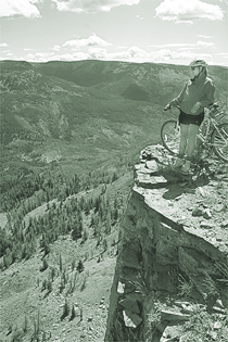
By and large, the main loop is void of eye-popping views of mountaintops, for the Uintas reveal themselves only shyly. For a grand panorama of Utah's tallest peaks, you must take the optional spur to the Bluffs Overlook. Here you'll be rim-rocked 2,500 feet above the Duchesne River Gorge and view a skyline stuffed with 12,000-foot summits.
Notes on the Trail
If you parked near Lambert Hollow (see Trailhead Access directions at end of story), simply ride south about 1 mile on Forest Road 037 to the junction with 304. (This is where the loop officially begins). Fork right and continue on 037 toward Wolf Creek and Camp Piuta. The moderately strenuous climb to Soapstone Pass is the loop's toughest stretch. At Soapstone Pass, fork left on Forest Road 089, a designated ATV route, toward Cold Spring. The dirt road darts into the conifers then skirts the perimeter of rolling meadows. A few gentle climbs are offset by mellow downhills.
At a T junction about 4.5 miles from Soapstone Pass, turn left on Road 174 for Cold Springs, which you pass 1 mile farther. Ignore the couple of doubletracks forking right farther along unless you want to explore around Lightning Ridge.
At the junction for Trail Hollow Trail on the basin's east side, turn right for the spur to the Bluffs; otherwise fork left on road 304 and climb a moderate hill to the Iron Mine Creek-Soapstone Creek divide. (Note: the 3-mile spur to the Bluffs is more mandatory than optional, so make the effort. Take Trail Hollow Trail downhill a few hundred yards and fork left on a doubletrack. Weave uphill through aspens then up a short but sharp incline. Ouch! Follow the faint doubletrack to the right. You'll know when to stop. Here, you'll teeter on the edge of 2,500-foot limestone escarpments that plummet to the banks of the Duchesne River. Glacially sculpted summits of the Uintas Mountains shape the northern skyline; many exceed 12,000 feet. The view is divine.)
The remainder of the loop descends gently through stands of aspens and fir. Generally, the dirt road is smooth and the pace is swift. Occasionally, you'll dodge a potpourri of rocks. Ride parallel to Soapstone Creek then cross it. You'll reach the loop's end about one-half mile farther.
Just the facts
Distance: 16.5-mile loop (including the 3-mile, out-and-back spur to the Bluffs)
Tread: Packed- and soft-dirt doubletracks with variable ruts and imbedded rocks.
Aerobic level: Moderate. The initial hill up to Soapstone Pass is the toughest, and it's not that bad. The rest of the time will be spent cruising on mostly fast-paced doubletracks.
Technical difficulty: Low. There are a few rocky stretches, especially on the loop's "back nine;" otherwise, it's mostly smooth sailing. During prolonged dry periods, the dirt can get thick and powdery.
Elevation change: The low point at the loop's beginning is about 8,500 feet. You'll knock off a 500-foot climb in 1.5 miles to Soapstone Pass. If you head up to the Bluffs, you'll top out at near 10,000 feet for a total gain of around 1,500-feet.
Trailhead access: From Kamas, drive 14.5 miles on UT 150 (Mirror Lake Highway). Be sure to bring along a few bucks to pay your "recreational use fee" at the toll booth. Turn right on Soapstone Road 037 and drive the all-weather dirt road (only a few rough spots for passenger cars) 2 miles to the junction with the Iron Mine Mountain Road. Fork right, continuing on 037 toward Camp Piuta and Wolf Creek Road. Lambert Hollow is 1 mile farther. Park at a backcountry campsite alongside the road or continue a mile farther to the junction of 037 and 304 to embark.
Excerpted from Mountain Biking Utah's Wasatch & Uinta Mountains, by Gregg Bromka.
 Back to Home Page