Mountain biking in Utah typically conjures up images of redrock canyons in the south and of alpine mountains in the north. But would you ever imagine riding on island trails engulfed by aquamarine water? In the Caribbean perhaps, but in Utah? Biking at Antelope Island State Park is a unique experience that will leave an indelible impression that is very different from the rest of the state.
Antelope Island is the largest of the Great Salt Lake's eight islands. Explorers Kit Carson and John C. Fremont named the island in 1845 for the abundant antelope they hunted, and Brigham Young ranged herds of livestock on Antelope shortly after the Latter Day Saints arrived in the Salt Lake valley.
Although the island's namesake pronghorns disappeared by the 1930s, a population was reintroduced in 1993 and thrives today. The island provides habitat for a variety of land animals including big horn sheep, coyotes, bobcats, badgers, jackrabbits and rodents. But the island is most famous for its bison herd, one of the largest publicly owned herds in the nation. Antelope Island is also a sanctuary for migrating and nesting birds that are drawn to the lake to gorge on the abundant insects and brine shrimp.
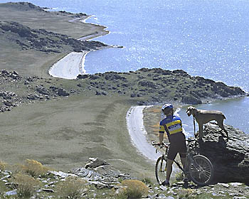
Nearly 45 miles of developed dirt roads and trails take bicyclists, hikers and equestrians from the lake's white sand beaches to the elevated terraces that are remnant shorelines of ancient Lake Bonneville - the Great Salt Lake's ice-age predecessor. The encompassing views of the inland sea, rocky island and distant mountains combined with scents of sea breezes are surreal, and sunsets on Antelope Island are always superlative.
Just the facts
Length: Up to 45 miles.
Tread: White Rock Bay Loop and half of Split Rock Bay Loop are doubletrack; other trails are singletrack.
Aerobic difficulty: Lakeside Trail is easy; White Rock Bay Loop is moderate because of one long climb; Elephant Head Trail is moderate because it requires the same solid climb on White Rock Bay Loop to reach it; Split Rock Bay Loop is moderate to strenuous; East Side Trail is moderate.
Technical difficulty: Moderate. Doubletracks and trails are mostly packed and loose sand with some gravel. There are intermittent sections of imbedded boulders and rutted tread. One short rock garden on the Lakeside Trail may require dismounting. The switchbacks on Split Rock Bay Trail can be tricky.
Elevation changes: The backcountry trailhead for White Rock Bay Loop is near shoreline at 4,200 feet. The Split Rock Bay Overlook rises to 4,860 feet; Beacon Knob on the White Rock Bay Loop is the high point at 4,960 feet. Gain for the White Rock Bay Loop is about 750 feet. Gain for the Split Rock Bay Loop is about 650 feet. Gain for the Lake Side Trail is trivial. The East Side Trail undulates between 4,200 feet and 4,500 feet.
Finding the trail: From I-15, take Exit 335 for Syracuse and Antelope Island State Park. Travel 7 miles west on Utah State Highway 108 to the park's entrance station and then cross the 7- mile long Davis County Causeway. Upon reaching Antelope Island turn left on the scenic loop road. Fork left on the East Side Road to reach the East Side Trail; otherwise, continue south on the scenic drive. Turn left at the Buffalo Point junction then right on a gravel road and follow signs to the backcountry trailhead, located just east of the group camping area. The Lakeside Trail trailhead is at the group camping area.
Notes on the trail
Lakeside Trail (4 miles out-and-back, or 6- mile loop): Beginners or families with children will enjoy this easy ride along the shore of the Great Salt Lake. Midroute, you will pass wooden benches from which you can watch the sunset or have a snack. The trail begins at the group camping area on White Rock Bay and travels 3 miles to the Bridger Bay campground. However, about 2 miles along the trail, you encounter a short bouldery stretch where you must dismount and walk several hundred yards, so turnaround here and return to the trailhead. Alternatively, you can ride this as a 6-mile loop (counterclockwise) by first pedaling up the gravel access road from White Rock Bay back to the Buffalo Point Junction. Follow the paved road north then fork left for Bridger Bay. Pedal through Bridger Bay campground to pick up the Lakeside Trail. Wrap around Buffalo Point, walking the bouldery stretch, and then coast to the White Rock Bay trailhead.
White Rock Bay Loop (8-mile loop): Start out from the backcountry trailhead and cross the grassy flats receding from the White Rock Bay shoreline. The doubletrack can be sandy at times and be peppered with rocks. As the trail veers away from the lake's edge, it rises deceptively to a junction. Fork left, plow through short sand traps and climb to the broad ridge. There's one steep, rough hill before you arrive at Beacon Knob where views are always spectacular. The Wasatch Range reflects off Farmington Bay to the east and the Great Salt Lake catches the setting sun to the west. Round a few sweeping turns and pass two gated roads to the right. Hold on tight for a fast, thrilling descent alongside a wire fence; then cruise back to the trailhead.
Elephant Head Trail (2.6 miles out-and-back): Take the White Rock Bay Trail 2.6 miles to the junction and fork right for the Split Rock Bay Overlook. Climb the steep hill to the overlook and to the junction for Elephant Head Trail. Take the singletrack right/west for 1.3 miles along the ancient shoreline to its end at a glorious viewpoint high above Split Rock Bay. Most of the trail is easy pedaling because it follows the old wave-cut bench, but brief sections can be moderate to highly technical because of loose tread, rocks and short steep hills. The "Elephant Head" is not discernable from this elevated angle. If you descend to Split Rock Bay and look back at the rocky point, you'll find that the profile of the low rocky point resembles a pachyderm sipping from the lake with its supine trunk.
Split Rock Bay Loop (5-mile loop): This ride follows both doubletrack and hand-built singletrack between Split Rock Bay and the Lake Bonneville bench. The singletrack traces the old shoreline through rugged terrain where rocks dating back 2.7 billion years are exposed as skeletal knobs and cliffs. Part of the Farmington complex, these striped and banded metamorphic rocks record the intense heat and pressure of their formation far beneath the earth's surface. Thereafter, the trail drops through a handful of switchbacks to arcuate beaches before rising back to the loop's trailhead.
East Side Trail (24-miles, out-and back): The latest addition to Antelope Island State Park is very different from the rest because it follows the island's east shore along the edge of Buffalo and Farmington Bays. The Wasatch Range, which towers above the metropolitan valley across the lake, is your constant companion and reflects off the lake's surface. The route roughly parallels the paved East Side Road and ends at the historic Fielding Garr Ranch south of Seagull Point. Built in 1948, the sun-dried adobe ranch was inhabited until 1981 when Antelope Island became a state park. This is a good route to view wildlife on shore, including bison, pronghorn antelope and big horn sheep and an array of waterfowl flocking to the lake's mudflat shore.
Fine print and backcountry policies: A fee is charged to cross the causeway to Antelope Island, whether you drive or pedal across. Permits (free) are required for backcountry travel. Pets must be on a leash at all times in the park. Backcountry trails are closed the last week of October for the annual bison roundup. Contact Antelope Island State Park for additional regulations: entrance gate: (801) 773-294; http://www.nr.state. ut.us/parks/utahstpk.htm
Naturally, do not approach bison or other wild animals because they are unpredictable and potentially dangerous. Feb-ruary through April and Sep-tember through November are ideal times to visit Antelope Island.
Excerpted from Mountain Biking Utah, 2nd edition, 1999; www.offroadpub.com/titles/1037.htm
 Back to Home Page